Colorado Landowner's Guide to Oil and Gas Development
The Guide
The Colorado Landowner's Guide to Oil and Gas Development is an educational guide intended for members of communities facing oil and gas development. The guide will be available for download in the coming days, in the meantime, please e-mail the author at mattsura.law@gmail.com if you are interested in a digital or print copy.
Forward
From 1996-2008, I worked as a community organizer for Western Colorado Congress—a non-profit community organization based out of Grand Junction, Colorado. As a community organizer in the Grand Valley, my job was to help our organization’s members be effective advocates on behalf of our community and the environment. Fighting for better regulation of the oil and gas industry eventually became my full-time job.
During those twelve years, Colorado experienced unprecedented growth in natural gas drilling. In 1996, there were approximately 17,000 oil and gas wells in Colorado.1 Now the state has over 50,000 active oil and gas wells.2 The number of drilling permits issued each year by the Colorado Oil and Gas Conservation Commission (COGCC) has gone up exponentially. In 2000 there were 1,529 wells permitted, doubling to 2,917 by 2004, and more than doubling again by 2008 to 8,027.3
Colorado’s gas development boom during the 2000s was in response to high market prices for natural gas and the discovery of marketable quantities of "non-conventional" resources like coal-bed methane and gas from tight sands formations. Improvements in drilling techniques and new technologies, such as hydraulic fracturing, have also given the industry access to oil and gas resources that were previously impossible to extract profitably.
Nowhere in Colorado was the increase in drilling, and the subsequent impacts on the land and communities, more dramatic than in Garfield County. For decades, the residents of the Grand Valley had little trouble accommodating the industry. There were gas wells, but they were spaced at least a half mile apart – at one well per 320 acres. As the price of natural gas shot up, and the Piceance Basin became known among the industry as the "Persian Gulf of natural gas"4, the oil and gas industry requested decreased spacing. First it was 80-acre spacing, then 40, then 20. Each well, and the associated roads, pipelines and production equipment, impacts three to five acres of land. At one well every 20 acres, the impacts in Garfield County were devastating—to the land, to wildlife, to the landowners, and to the communities living among the gas wells.
For ten years I worked with community members in the Grand Valley Citizens Alliance—the Garfield County chapter of the Western Colorado Congress. Some days were spent meeting with landowners who had water wells contaminated by natural gas from nearby drilling. On other days, we were hosting media tours of Divide Creek—a stream that could be set on fire as a result of a seep from a nearby gas well. We took media and local government officials on single-engine airplane flights over lands drilled at ten-acre densities so they could gain a new perspective of what was happening on the ground. Every year, we would meet with our allies—communities struggling with the same issues in the San Juan Basin, as well as the Raton, Paradox, and Denver-Julesberg basins. Every year we traveled to Denver in order to attend state oil and gas hearings, testify at state health department hearings, and encourage improvement of the oil and gas laws and regulations in our state. Every year we would mourn the Colorado General Assembly’s failure to pass oil and gas reform at the state capitol.
Finally, in 2007 and 2008, Colorado passed sweeping improvements to our oil and gas laws and regulations. Most of the COGCC’s rules that protect landowners and the environment were adopted in 2008. It was that experience that led me to attend law school so I could help affected communities use the new laws that were meant to protect them.
I hope that anyone who wants to participate in decisions regarding oil and gas development in their community finds this guide helpful. Landowners faced with the prospect of oil and gas development on their property are more or less forced to engage in the oil and gas decisions affecting their land, so this guide is written with them in mind. This guide is also meant to give affected communities some insight into how Colorado’s oil and gas laws and regulations can be used to prevent unnecessary impacts to the environment and nearby residents.
I appreciate any comments that would make the Colorado Landowner’s Guide more useful. Please feel free to write with any comments to: mattsura.law@gmail.com.
1. Interview with Thom Kerr, Permitting Manager, COGCC, in Denver, Colo. (April 11, 2011). [back]
2. "Oil and Gas Staff Report", COGCC, May 6, 2013, pg. 24. [back]
3. "Oil and Gas Staff Report", COGCC, May 6, 2013, pg. 18. [back]
Matt Sura is an oil and gas attorney who specializes in the representation of land owners, mineral owners, and local governments.
From 1996-2008 Matt worked with Western Colorado Congress – a non-profit organization based in Grand Junction, Colorado. During his time on the Western Slope, Matt worked with rural residents and communities that were struggling with oil and gas development occurring on their land and throughout the region.
Matt became an attorney so he could better assist families, communities, and local governments in their negotiations and legal disputes with the oil and gas industry. Matt's practice also emphasizes real estate, environmental, and administrative law.
Matt Sura, Esq. • mattsura.law@gmail.com • 720-563-1866 • http://www.mattsuralaw.com/
I would like to thank and highlight the following organizations for their support of the Landowner’s Guide.
PUBLIC COUNSEL OF THE ROCKIES
Public Counsel "balances the scales" on conservation, energy & water, and public justice issues. As a regional and largely virtual public interest law firm, Public Counsel develops, funds, and coordinates professional teams, putting private funding next to the best talent in the region around good ideas.
Public Counsel earmarks and leverages grants and contributions to mobilize and deploy highly-qualified project teams, working at half-market instead of pro-bono. We link seasoned contract professionals to pivotal issues, and leverage funds earmarked by donors for each project. By using Internet technology, we make it possible for legal and other experts to work remotely and cost-effectively, collaborating in "virtual offices" to develop effective responses to threats to natural ecosystems, and the social fabric of the Rocky Mountain region.
INTERMOUNTAIN OIL AND GAS BMP PROJECT
The Intermountain Oil and Gas BMP Project was developed by the Getches-Wilkinson Center for Natural Resources, Energy, and the Environment at the University of Colorado Law School. This website (http://www.oilandgasbmps.org) is a searchable database addressing surface resources affected by oil and gas development. The database includes both mandatory and voluntary Best Management Practices currently in use or recommended for responsible resource management in the states of Colorado, Montana, New Mexico, Utah, and Wyoming.
OTHER ACKNOWLEDGEMENTS
I would also like to acknowledge the excellent research, editing, and technical assistance I received from Sean Owens, Luke Mecklenburg, and Josh Kruger. I would especially like to thank Tim McFlynn, Kathryn Mutz, Matt Samelson, and Charles Wilkinson for their support of this project.
Finally, I want to acknowledge Western Colorado Congress, Grand Valley Citizens Alliance, and the many hard-working and committed individuals I have worked with in the gas patch who continue to serve as my inspiration.
Contents
I. INTRODUCTION II. OIL AND GAS REFORM COMES TO COLORADO III. REGULATORY AUTHORITY OVER OIL AND GAS DEVELOPMENT
A. The Commission
B. COGCC Staff
C. Other State Agencies 1. Colorado Parks and Wildlife (CPW) 2. Colorado Department of Public Health and the Environment (CDPHE) 3. Colorado State Land Board (SLB)
D. Local Government Authority over Oil and Gas Operations
E. Federal Government – Bureau of Land Management IV. BASICS OF OIL AND GAS DEVELOPMENT V. DETERMINING IF YOU HAVE MINERAL RIGHTS
A. Split Estate Background
B. Researching Mineral Ownership
C. Advantages of Mineral Ownership VI. NEGOTIATING WITH THE OIL AND GAS INDUSTRY
A. Increasing Your Negotiating Leverage 1. Educating yourself about your rights and current market conditions 2. Joining together with your neighbors 3. Obtaining Legal Counsel 4. Negotiating a Mineral Lease
B. A Protective Lease 1. Fair Compensation 2. Fair Lease Terms 3. Surface Protections
C. Surface Use Agreement
D. "Bonding On" without a Surface Use Agreement VII. ORGANIZING THE FIELD - SPACING
A. COGCC Well-Density Orders and Local Public Forums
B. Directional Drilling and Multi-Well Pads
C. Forced Pooling VIII. LOCATING OIL AND GAS WELLS AND OTHER FACILITIES
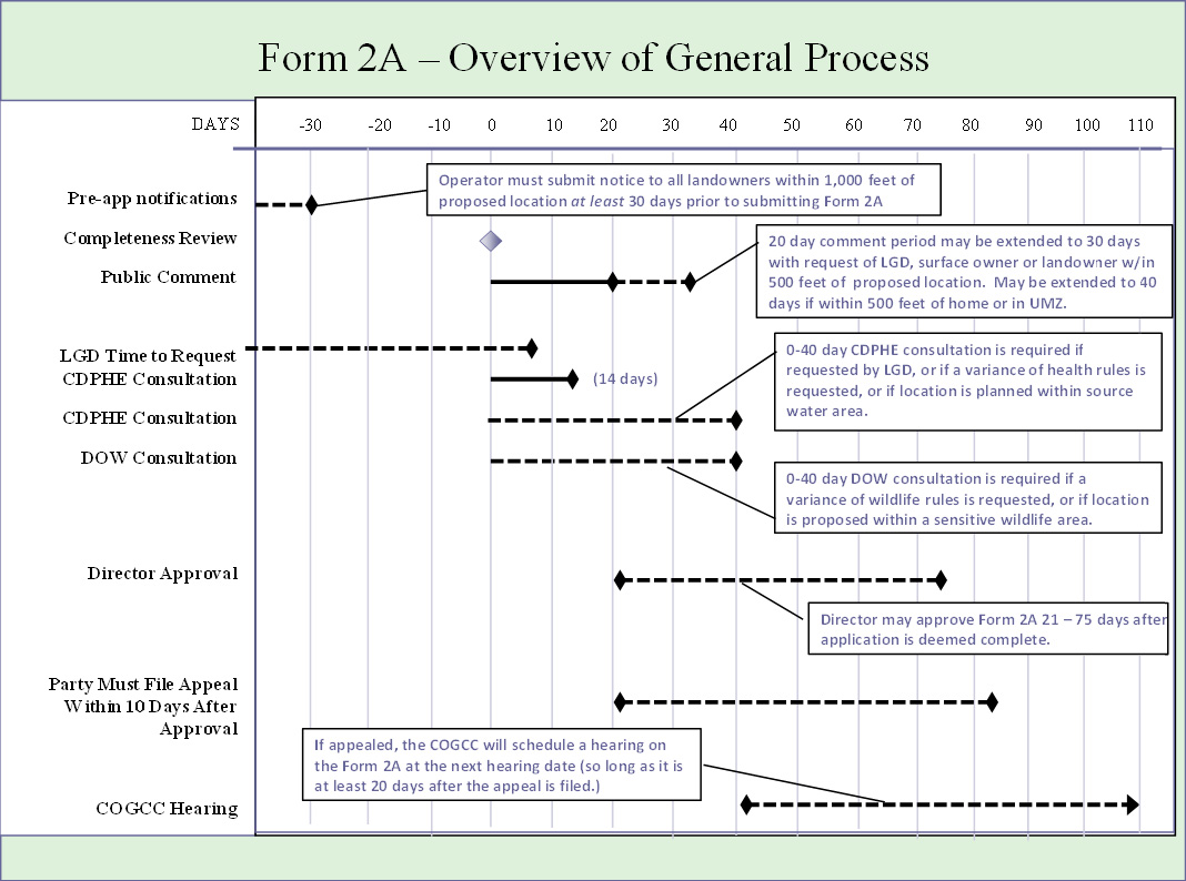
A. Oil and Gas Location Assessment
B. Public Notification
C. Application For Permit To Drill (APD)
D. Public Comment
E. Required Consultation
F. Appealing Decisions to the COGCC IX. REGIONAL PLANNING
A. Comprehensive Drilling Plans (CDP) (Rule 216)
B. Geographic Area Plans (GAP) (Rule 513)
C. Regional Agreements Not Covered in the COGCC Rules 1. Regional Planning Required by Local Government 2. Neighborhood Lease Agreements 3. Good Neighbor Agreements X. SURFACE PROTECTIONS
A. Seismic Testing
B. Reclamation (1000 series Rules) 1. Surface Owner Consultation 2. Site Selection and Preparation 3. Interim Reclamation Requirements and Weed Control 4. Final Reclamation Requirements
C. Erosion Control – Stormwater Regulations (1000 series Rules)
D. Livestock Protections XI. REGULATION OF OPERATIONS CLOSE TO HOMES
A. No Health-Based Protections in Colorado
B. Setbacks from Homes and "High Occupancy Buildings" 1. The "Non-Urban" Exception 2. The Current Well Location Exception 3. The Surface Use Agreement Exception 4. Variance 5. High Occupancy Buildings
C. Best Management Practices for Oil and Gas Development Near Homes XII. HYDRAULIC FRACTURING
A. How Much Water is Used by Hydraulic Fracturing?
B. Is Hydraulic Fracturing a Threat to Water Quality?
C. What is in Hydraulic Fracturing Fluid? XIII. WATER QUALITY PROTECTION
A. Spills
B. Methane Contamination of Water Wells
C. Water Testing by the COGCC
D. Water Quality Monitoring
E. Waste Storage and Disposal (pits, injection)
F. Watershed Protections
G. Protecting Water Supplies near Coal-Bed Methane Production 1. Costs and Benefits of Adjudicating Your Water Right 2. How to Adjudicate Your Water Right XIV. AIR QUALITY
A. Ozone
B. Odor
C. Dust XV. NOISE XVI. WILDLIFE PROTECTIONS (1200 SERIES RULES)
A. Wildlife Maps
B. CPW Consultation – Wildlife Mitigation Plans
C. Sensitive Wildlife Habitat
D. Restricted Surface Occupancy Areas (Rule 1205) XVII. COGCC – GENERAL PROCESSES AND PROCEDURES
A. Hearings before the COGCC 1. Intervention in an Adjudicatory Hearing 2. Requesting a Hearing
B. Variances
C. Rulemaking XVIII. RULE VIOLATIONS
A. Filing a Complaint with COGCC
B. Notice of Alleged Violations (NOAV) XIX. CHALLENGING A LEASE OR ROYALTY PAYMENTS
A. Requirement to Market Oil and Gas
B. Failure to Pay Royalties
C. Failure to Pay the Correct Amount of Royalties XX. CONCLUSION APPENDIX 1: CONTACTS FOR MORE INFORMATION APPENDIX 2: USING THE COGCC MAP APPENDIX 3: FREQUENTLY USED ACRONYMS APPENDIX 4: OTHER HELPFUL DOCUMENTS
Landowners gained a few important rights from the oil and gas reforms passed in 2007-2008. But landowners, and nearby communities, still face an uphill battle when participating in oil and gas development decisions. Where oil and gas exists, it is likely to be developed. How it is developed, and what protections are put in place for public health, safety, and welfare and the environment are decisions that the landowner should be able to influence.
Landowners can gain leverage in the oil and gas decisions affecting their land by:
• Owning their mineral rights: Ownership of "mineral rights" (which includes rights to oil and gas) gives a property owner real leverage with oil and gas companies—the landowner has something that the oil and gas companies want. Ownership of mineral rights also gives a property owner better access to COGCC decision processes that affect both the mineral rights, and surface property rights.
• Organizing their neighbors: Neighbors sharing information and being willing to organize their efforts when dealing with oil and gas operators can give landowners much more leverage with the operators, their local government, and the COGCC, than they could have alone.
• Negotiating with the oil and gas operator: A landowner without mineral rights can still gain valuable protections for his property through negotiations with the oil and gas operators. Direct communication with the operators is often the best way to solve problems in the oil and gas patch.
• Meeting with local government and local government designee: Local governments have the ability to assign a "local government designee" to monitor oil and gas development. The designee has more access to COGCC processes and thus more ability to affect COGCC decisions. Local governments also have additional regulatory powers of their own— should they choose to use them. Appendix 1 contains a link to the COGCC’s list of local government designees.
• Educating themselves about their rights: To effectively protect their property, or their community, it is helpful for landowners to know their legal rights, as well as to understand the legal rights and responsibilities of the oil and gas operators.
Oil and Gas Regulation before 1996
The Colorado oil and gas industry, until recently, has enjoyed an extremely lax regulatory environment. Historically, the size and scope of the industry allowed it to escape regulation. Before the 1990s, development of oil and gas typically was done by drilling one well every 80 acres. In a state containing vast stretches of unoccupied land, the damage to the environment was minimal and impacts were easily overlooked. In 2007, the Fraser Institute ranked Colorado as the best place in the world to develop oil and gas.5 The report concluded that Colorado’s minimal regulations and low severance taxes made oil and gas development in Colorado as desirable as development in Malaysia, Romania, Qatar, and Thailand.
The industry also benefited from unqualified support of the elected officials in state government. Colorado has had a moderate amount of oil and gas activity since the late 1800s—subject to the boom and bust cycles common to the industry. The long-term presence of the industry in the state, and the higher-paying jobs it provided, gave the industry a disproportionate share of political influence in state government.
This political influence was most apparent during the two terms of Colorado Governor Bill Owens from 1998 – 2006. A former lobbyist for the oil and gas industry, Governor Owens ensured that the COGCC, the state agency that regulates oil and gas, was stacked with commissioners friendly to the industry. The oil and gas statutes at the time required the Governor to appoint five out of seven COGCC commissioners with "substantial experience" in the industry. Governor Owens appointed six of seven commissioners who were simultaneously earning salaries as oil and gas industry executives. One commissioner was an executive from an oil company that had the distinction of committing more violations of COGCC regulations than any other operator in the state.6 While that background may have given the commissioner "substantial experience" in COGCC regulations, it hardly gave the public much confidence in the COGCC.
In the 2000s, conflicts with landowners and the industry increased. At the same time oil and gas was booming, Colorado was also experiencing one of the highest population growth rates in the country. While new homes were being built in rural areas, the oil and gas industry was drilling more wells within those same rural areas. In some regions of Colorado, the industry now drills one well every ten acres. Given the lack of landowner protections in Colorado’s oil and gas regulations, the clash of those who own mineral rights and those who own the surface property was unavoidable.
The exponential growth of the oil and gas industry over the past decade also led to environmental impacts that could no longer be ignored. Drilling within watersheds that provide domestic drinking water, a number of highly publicized oil and gas industry accidents, and the impact to Denver-area air quality from nearby gas fields, finally caught the attention of the public and elected officials.
New Era of Oil and Gas Regulations
In 2006, the election of Governor Bill Ritter marked the end of the lax regulatory environment for the oil and gas industry in Colorado. As a candidate, Governor Bill Ritter promised to change the structure of the oil and gas commission and to require new regulations that would better protect the environment and communities living within and near gas development.
In 2007, the Colorado legislature passed a law that promised to change oil and gas regulation in Colorado. The Colorado Oil and Gas Conservation Commission Reform (H.B.07-1341) provided for broader representation and expertise on the COGCC and required it to adopt new rules to better protect public health, welfare, and the environment. After one year of work and more than 80 hours of hearings, the oil and gas commission completed an extensive rewrite of its rules in December 2008. The 2008 COGCC regulations are common-sense protections of landowners’ rights, water quality, air quality, wildlife, and public health.
In 2009, Colorado started to see a decline in the number of wells being drilled. Some in the oil and gas industry blamed this decline on the new regulations passed the year before. But new regulations were not driving a decline in drilling... it was the prices. Horizontal drilling and multi-stage hydraulic fracturing were unlocking the oil and gas contained huge shale deposits throughout the United States. New oil and gas production booms in North Dakota, Pennsylvania, Louisiana, Texas and other places caused the price of natural gas to plummet. With prices so low, and regional pipelines at capacity, it no longer made economic sense to drill for natural gas in Colorado.
At the same time the price of natural gas was falling, the price of oil started a rapid rise from nearly $40 a barrel in late 2008 to over $100 a barrel in 2010. The price of oil has stayed near $100 a barrel since 2010 even though oil production in the United States has increased dramatically.
These high oil prices eventually led to a mini-drilling boom on Colorado’s Front Range. The Niobrara shale formation, extending from southern Douglas County into southern Wyoming, has shown some promise as an oil-producing formation. While drilling in the Niobrara has not produced the consistently profitable wells industry has found in North Dakota, the high price of oil still makes drilling in the northern portions of the Niobrara very profitable. Industry literature, investor presentations, and various studies suggest a typical Niobrara horizontal well costs $4 to $5 million with an estimated ultimate recovery of 335,000 barrels of oil.7 At a conservative $80 a barrel, wells in the Niobrara are netting over $20 million. Most of this profit is realized in the first few years when a well’s production is highest.
Since adoption of the 2008 regulations, Colorado oil production has doubled, reaching historic highs. Most of the new oil and gas activity is happening in one corner of the Niobrara –Weld County. In 2012, nearly 50% of the state’s new well permits were for locations in Weld County. Oil and gas production in Colorado is not going away anytime soon.
In addition, the oil and gas industry continues to spend money to influence state government. In 2010, the oil and gas industry donated more than $360,000 to races in Colorado.8 In the race for Governor, two of the three candidates promised to "roll-back" the new COGCC regulations.
5. Fraser Institute, Global Petroleum Survey, December 2007. (The Fraser Institute is a Canadian conservative/libertarian think-tank similar to the Cato Institute in Washington DC. The survey "was designed to determine in which jurisdictions public policy factors, such as taxation and regulation, and the business environment more generally, constitute significant barriers to investment" in oil and gas development. The report ranked Colorado as the best place in the world to invest in oil and gas development. "…Malaysia, Romania, Qatar, Thailand, and Colorado are the most attractive locations for upstream petroleum investment.") [back]
6. In 1999, Governor Owens appointed Brian Cree of Littleton to the COGCC. Cree was an executive officer with Patina Oil & Gas Corp. that held the distinction that year of being cited for more violations of COGCC rules than any other oil and gas corporation in Colorado. (Data obtained from theCOGCC website (running search through database (search "inspection/incident inquiry" then "NOAV" (Notice of Alleged Violations))). [back]
8. Data obtained for 2010 from www.followthemoney.org looking at both donations to candidates and political party committees. [back]
The Colorado Oil and Gas Conservation Commission (COGCC) is the state agency, under the Department of Natural Resources (DNR), that has regulatory authority over most oil and gas development in the State of Colorado. The COGCC is in charge of all state permitting of oil and gas activities as well as writing the rules and regulations that the oil and gas industry must follow when exploring, drilling, and producing oil and gas in Colorado. Indian trust lands and reservations are not subject to COGCC oil and gas regulations (Rule 201) but development on other federal lands must comply with COGCC rules as well as federal regulations.9
The COGCC is led by nine commissioners who make rules and decisions consistent with the state statutes in the Oil and Gas Conservation Act C.R.S 34-60-101 (the "Act"). The Act was amended in 2007 to require greater protection for the environment and wildlife. The COGCC now must balance the rights of the industry with an obligation to protect public health and our environment.
The mission statement of the COGCC now reads,
"It is declared to be in the public interest to: Foster the responsible, balanced development, production, and utilization of the natural resources of oil and gas in the state of Colorado in a manner consistent with protection of public health, safety, and welfare, including protection of the environment and wildlife resources; [and] plan and manage oil and gas operations in a manner that balances development with wildlife conservation in recognition of the state's obligation to protect wildlife resources and the hunting, fishing, and recreation traditions they support, which are an important part of Colorado's economy and culture… it is the policy of the state of Colorado that wildlife and their environment are to be protected, preserved, enhanced, and managed for the use, benefit, and enjoyment of the people of this state and its visitors."10
Many read the mission to be an often conflicting dual-mandate to both promote oil and gas extraction and to protect public health. Although the mission was much improved in 2007, there is still concern that the mission of the COGCC should not require the oil and gas regulatory agency to "foster" oil and gas production.11
An important part of the 2007 COGCC reform effort was to change the composition of the COGCC. The Commission has long been derided as the "fox guarding the henhouse" when five of seven Commissioners were required to have "substantial experience" in the oil and gas industry. As a result of the 2007 legislation, the COGCC has been expanded to nine members – only three of which must have a background in the industry.12 The directors of the Department of Natural Resources and the Department of Public Health and the Environment (CDPHE) have permanent seats on the Commission. All of the other Commissioners are unpaid four-year gubernatorial appointees that must be confirmed by the state Senate.
The COGCC is now comprised of the following:
• The Director of the Department of Natural Resources
• The Director of the Department of Public Health and Environment
• Three members with industry expertise (two of which must have a degree in petroleum geology or petroleum engineering)
• One member with training or substantial experience in environmental or wildlife protection
• One member with training or substantial experience in soil conservation or reclamation
• One member is a local government official (typically from a region with substantial oil and gas development)
• One member is actively involved in agricultural production and is also an oil and gas royalty owner
Other sideboards on the appointments require that no more than four Commissioners from one political party may be appointed (not including the directors of the DNR and CDPHE) and that two of the Commissioners must come from the Western Slope of Colorado.
Understanding the makeup of the Commission is important for anyone wanting to influence a decision about oil and gas development in Colorado. The Commission is no longer comprised of a majority of oil and gas executives. Since 2007, the new Commissioners have worked hard to adopt strong oil and gas rules to better protect public health, property owners, the environment, and wildlife. Criticism of the Commission for being too closely-aligned with the industry is not justified and would be counter-productive to those attempting to influence Commission decisions.
It is also important to know what areas of expertise each member brings to the Commission, as well as where the Commissioners live. Commissioners may attend community meetings in their area or discuss general COGCC matters with concerned citizens. Commissioners will often defer to a fellow Commissioner who has expertise in a certain issue, or who lives near an oil and gas development and brings "on the ground" knowledge of the issue.
Meeting or communicating with commission members outside of a formal COGCC hearing is called "ex-parte communications." Ex-parte communications with individual Commissioners are allowed unless the issue has already been noticed for a COGCC hearing. (Rule 515). Therefore, on issues involving individual well permits, rule violations, or spacing decisions (public issues hearings), citizens may contact individual Commissioners to express their concerns, so long as the issue has not been noticed on a COGCC meeting agenda. Future COGCC meeting agendas can be found on the COGCC’s website.13
In rulemaking hearings, ex-parte communications with Commissioners is allowed until public comment on the rulemaking is closed.
The Commissioners who have an oil and gas background are permitted to participate in COGCC decisions that affect their industry, or even their own company. If a concern about a conflict of interest is raised by any party, or by the public, and the Commissioner does not choose to withdraw, then the Commission shall vote on whether a conflict of interest exists. (Rule 516(b)). Such votes are extremely rare on the Commission.
A listing of the Commissioners, their backgrounds, and where they are from, is posted on the COGCC website.14
Along with the Commissioners, the COGCC also has over 70 full-time staff who handle the majority of the COGCC’s day-to-day issues. Most drilling permits, for example, are approved by the COGCC staff on behalf of the Commission. The staff is led by the COGCC Director. A listing of these staff members, and their individual extensions, is located on the COGCC website.15
The COGCC’s headquarters is in downtown Denver but there are also Field Offices located near most active oil and gas fields in the state. Knowing the local field inspectors can be useful for ensuring timely resolution of complaints, and for helping to resolve conflicts with operators.
1. Colorado Parks and Wildlife (CPW)
In 2007, H.B. 1298 was passed to address the impacts oil and gas development has on wildlife. This new legislation, and the rulemaking to implement it, increases the ability of the Colorado Parks and Wildlife (CPW) to influence oil and gas decisions that might adversely affect wildlife.
The CPW, like the COGCC, is also housed within the Department of Natural Resources. As will be discussed in the wildlife section, if the proposed development falls within a mapped sensitive wildlife area, the CPW has the ability to recommend "conditions of approval" for new drilling applications to protect wildlife or mitigate negative effects to wildlife. The COGCC staff is the final authority as to whether or not to require CPW’s proposed mitigations as an enforceable condition of approval on the drilling permit. The CPW does not have the ability to prohibit drilling or to override COGCC decisions.
2. Colorado Department of Public Health and the Environment (CDPHE)
The Colorado Department of Public Health and the Environment (CDPHE) is a separate agency from the Department of Natural Resources. The Director of the CDPHE is a cabinet-level position, is appointed by the Governor, and is a permanent voting member of the COGCC. Like the CPW, the CDPHE can propose conditions on some drilling permits and on all comprehensive drilling plans. Whether the conditions are made part of the drilling permit is at the discretion of the COGCC staff.
The CDPHE has created a state map of "water supply areas"—lands near rivers, streams, and wells that are used to supply drinking water. Oil and gas development is not to occur within 300-feet of these protected water sources. Other restrictions are also applicable up to a half-mile from these water sources. See Section XII. Water Quality Protection for more information.
3. Colorado State Land Board (SLB)
The Colorado State Land Board (SLB) is also under the Department of Natural Resources and the Board members are appointed by the Governor.
Except for the federal government, the SLB is the largest landowner in Colorado. When Colorado became a state in 1876, the U.S. government granted the State of Colorado, sections 16 and 36 from each township in the state to be used "for the support of common schools."16 A section is one square mile (640 acres). Upon statehood, Colorado held nearly 4.5 million acres in state trust lands. Today, the SLB still owns nearly 3 million surface (land) acres and over 4 million subsurface (mineral) acres.
The SLB manages its properties to benefit the School Trust and seven smaller trusts.17 Much of the income generated by the SLB comes from oil and gas royalties and bonus payments from leasing oil and gas development on its properties. It is state policy that state lands will be leased if there are interested operators. Recently, the new development in the Niobrara formation has led the SLB to receive record bonus payments from leasing new areas along the Front Range.
Under the Colorado Constitution, the SLB has a "fiduciary" responsibility to these beneficiaries to produce "reasonable and consistent income over time." But the SLB also must manage its land with "sound stewardship, including protecting and enhancing the beauty, natural values, open space and wildlife habitat thereof, for this and future generations."
This "sound stewardship" mandate seems to have been lost on the current Board members and their staff. Recent changes in the standard SLB lease offer fewer surface and landowner protections than the standard lease the SLB had been using since 1988.18
Depending on the makeup of the Board, and the land proposed for development, the SLB may be willing to include additional lease conditions in order to reduce impacts to local communities or the environment. In 2011, the SLB did bow to public pressure by delaying the leasing of state lands in the South Park Basin due to concerns about wildlife and water quality.19 The SLB has also been in discussions with the City of Fort Collins about a collaborative project to protect lands that may be leased within the Ft. Collins "Natural Areas" program.
One of the more controversial subjects in recent years has been the role of local governments in the regulation of oil and gas development. The Colorado Constitution and legislature has given local governments the ability to control land use through planning and zoning. Local governments also have been granted broad "police powers" that enable them to pass ordinances to protect the public. These police powers include zoning and general land use authority that was commonly applied to the oil and gas industry.
The COGCC was established in 1951 but it was not until 1992 that the Colorado Supreme Court defined the preemption doctrine in use today.20 See preemption section below for more information.
No matter how the preemption debate continues to unfold in the courts, there are some areas where local government has an indisputable role to play in the regulation of oil and gas in Colorado. These areas of local government regulation can be broken down into two categories: 1) Local government authority through COGCC regulations, and 2) Areas of exclusive local government authority.
Anyone concerned about oil and gas development on private property should determine if there are any relevant local government oil and gas regulations, and meet with the local government representatives charged with permitting and monitoring oil and gas in that area.
Local government authority through COGCC regulations: COGCC regulations give local governments some power to influence COGCC decision-making through the appointment of a Local Government Designee (Designee). The Designee serves as a primary local government contact for the oil and gas industry and a liaison between the local government and the COGCC. In some cases, COGCC rules require that a Designee is appointed before that local government can participate in COGCC decisions.
The COGCC Rules grant local governments, through their Designees, the following rights:21
• The right to participate in the development of comprehensive drilling plans (Rule 216);
• Special notice of permit applications and location assessments, permit and assessment decisions, and the commencement of heavy equipment operations (Rule 305);
• The right to extend the comment period on certain applications from 20 to 30 days (Rule 305);
• Consultation with operators regarding the location of roads, production facilities, and well sites (Rule 306);
• The right to request CDPHE consultation regarding public health, safety, welfare, and environmental concerns (Rule 306);
• The right to request a variance from COGCC regulations (Rule 503);
• The right to request a commission hearing on the approval of a drilling permit or location assessment (Rule 503);
• The right to request a local public forum in connection with an application for increased well density (Rule 508).
For the rules listed above, the Designee is the sole voice for community concerns. Only a Designee may request the extension of a comment period, request a hearing on a drilling permit, request a local public forum, or request that the CDPHE is consulted.
Designees, and the local governments they represent, vary greatly in their effectiveness at representing citizen concerns in COGCC procedures. Many of the Designees have a limited understanding of COGCC regulations, have many other assignments in addition to their role as Designees, or are not able to act without authorization from the elected officials. In areas experiencing heavy oil and gas development, community members may want to request that the local government allocate a full-time employee for the position.
Community members who want their local government to become involved in a COGCC decision will want to meet with their Designees well ahead of any COGCC action. Meeting with the Designee is critical to ensure that the Designee understands community concerns and the local government’s ability to participate in COGCC decisions. Community members will also want to determine if the Designee needs authorization from elected officials to participate in the COGCC decision. Without some independent authority to act, the 20-day comment period will likely expire before the elected officials hear about the issue and take action.
Areas of exclusive local government authority: Local governments have exclusive legislative authority to regulate some aspects of oil and gas development such as transportation and emergency response. In other areas, such as land use, the local government has authority that seems to overlap with the authority of the COGCC. These "gray areas" in the law are the subject of numerous lawsuits.
Local governments are far more accessible and responsive to community members than the COGCC or the state legislature. When oil and gas development begins causing concerns among the local population, many local governments have responded by passing additional requirements for oil and gas development in those areas—typically through conditional use permits (also called special use permits). While local government probably cannot stop drilling,22 requiring operators to get a conditional use permit enables the local government to place additional conditions on wells and other oil and gas activities. Conditional use permits typically allow for public input in the form of written comment or public hearing.
In home rule counties and municipalities, citizens also have the ability to petition to place a citizen-initiative on the local ballot.23 In 2006, a successful citizen initiative effort led to the adoption of a municipal watershed ordinance in Grand Junction, Colorado. The ordinance requires additional water quality protections for oil and gas operators drilling within the city’s municipal watershed.24 Another recent citizen initiative led to an outright ban of the use of hydraulic fracturing within the city limits of Longmont. The oil and gas industry has sued over the ban of hydraulic fracturing and claims the ban is preempted by the state.
Preemption: The extent to which local governments may regulate oil and gas activities has been limited by several court decisions. The Colorado Supreme Court has found that local governments may only regulate oil and gas so long as the regulations do not "operationally conflict" with the state interest of "foster[ing] the responsible, balanced development, production, and utilization of the natural resources of oil and gas in the state of Colorado in a manner consistent with protection of public health, safety, and welfare, including protection of the environment and wildlife resources."25,26 A local regulation will be found to operationally conflict with the state’s interest if the industry or state is able to show, based upon a fully developed evidentiary record, that the local regulation, "materially impairs or destroys" the state interests. This is a tough standard to meet. Most local regulations are not preempted.
Recently, the COGCC decided to sue the City of Longmont because the City enacted zoning regulations to limit where the oil and gas operations may occur. Zoning has been used in the United States since 1916. In its earliest applications it was primarily used to separate industrial from residential uses.27 Texas allows the local governments to determine their own appropriate setbacks from homes. Tulsa, Oklahoma, which once called itself the oil capital of the word, has banned oil and gas development within its borders.28 In Colorado, local zoning applies to most industrial development. However, Governor Hickenlooper has determined that the State of Colorado will not allow the application of local zoning to oil and gas development – giving an exception to the oil and gas industry not enjoyed by any other industry in Colorado.
In an effort to avoid the possibility of a lawsuit with the COGCC, local governments tend to limit their oil and gas regulations to issues that COGCC regulations do not exhaustively cover, such as road maintenance, permitting of temporary living quarters for workers (man-camps), and storage yards. Local governments may also require the operator to provide additional information during a local permitting process, beyond the information the operator provides to the COGCC.
Several counties have devised creative approaches to regulate the industry while not coming into "operational conflict" with COGCC regulations. Gunnison County, for example, has adopted "Performance Based Regulations" in order to avoid operational conflicts with COGCC rules. The county lists the problems that can be caused by oil and gas operations, (such as water quality concerns) and then requires the operator to offer proposed solutions to those problems as part of its conditional-use permit application. Applications are evaluated based on how well the operator will avoid or mitigate impacts.29 If the proposed plan or mitigations are deemed insufficient, the County retains the ability to deny the permit. By using performance based regulations, Gunnison County avoids having specific regulations conflict with COGCC rules, uses industry expertise in arriving at solutions, and retains the leverage to obtain protections that go beyond COGCC regulation requirements.
Boulder County has opted to use a carrot-and-stick approach to regulating the industry. Boulder County has two tracks. The first, called the "expedited development plan review process," promises a relatively quick review and approval by the staff – so long as Boulder County’s "objective criteria," which is far more protective of public health and welfare than COGCC rules, are met. On the other hand, a company choosing to do only the minimum required by the COGCC will be sent to through the "standard development plan review process." The standard review process requires a public hearing and a vote by the planning commission, followed by another public hearing and a vote by the Board of County Commissioners. If the project is controversial, the standard review process may take months.
Some municipalities have taken the approach of creating "memorandums of agreement" with specific oil and gas companies that want to operate within that municipality. Those municipalities choose this approach because it avoids the question of preemption, the municipality is able to negotiate greater protections than are required by state law, and it starts a cooperative relationship with the industry. Industry prefers a memorandum of agreement as well because it avoids lawsuits and gives the industry the certainty of knowing the requirements it will have to follow in order to operate within that jurisdiction.
This guide is not meant to cover federal oil and gas regulation of federal lands.30 However, the federal government does own minerals beneath some private land in Colorado. The federal guidelines for oil and gas operators drilling on federal land, or on private land with federal minerals, are contained in "Surface Operating Standards and Guidelines for Oil and Gas Exploration and Development" more commonly referred to as, "The Gold Book."31 For all development of federal land, or private land with federal minerals, the Bureau of Land Management has prepared a Resource Management Plan (RMP). The RMP is intended to address all "reasonably foreseeable" oil and gas development within the geographic region covered by the plan. If an issue arises over exploration or development of federal minerals, an affected landowner should become familiar with the Gold Book, the RMP, and any lease conditions the federal government has placed on the operator. It is also helpful to meet with local BLM officials to discuss any concerns.
COGCC regulations still apply to the development of federal minerals under private land.32 In most cases, the RMP, and requirements listed in federal leases, offer few, if any, additional protections for the landowner.
9. Statement of Basis, Specific Statutory Authority, and Purpose: New Rules and Amendments to Current Rules of the Colorado Oil and Gas Conservation Commission, 2 C.C.R. 404-1 (2010). [back]
11. See HB 13-1269 by Rep. Foote (D-Longmont) (One bill provision would have changed the mission of the COGCC to simply focus on protection of public health and the environment. Bill failed in the State Senate.) [back]
18. See State Board of Land Commissioners, Standard Lease, revised 03/2011. The new standard lease removed language that allowed damage to the surface only if it was "reasonable and necessary" and drilling set-backs from homes that protected surface owners.) [back]
20. Bd. of County Comm'rs, La Plata County v. Bowen/Edwards Assocs., 830 P.2d 1045, 1045 (Colo. 1992). [back]
21. GERALD DAHL, ET AL., OIL AND GAS REGULATION: A GUIDE FOR LOCAL GOVERNMENTS, COLORADO DEPT. OF LOCAL AFFAIRS (2010), no longer available online. [back]
22. Voss v. Lundvall Brothers, Inc., 830 P.2d 1061 (Colo. 1992) (City of Greely, a home-rule city, attempted to ban oil and gas drilling within the City limits. The Colorado Supreme Court held: "while the Oil and Gas Conservation Act does not totally preempt a home-rule city's exercise of land-use authority over oil and gas development and operations within the territorial limits of the city, the statewide interest in the efficient development and production of oil and gas resources… prevents a home-rule city from exercising its land-use authority so as to totally ban the drilling of oil, gas, or hydrocarbon wells within the city.") [back]
23. Colo. Const. Art. V §1(9) (Counties and municipalities that are not home rule do not have the power of citizen initiative. There are currently two home rule counties: Pitkin County and Weld County. A listing of the 98 home rule municipalities in the state can be found at the CO Dept. of Local Affairs website) [back]
32. Statement of Basis, Specific Statutory Authority, and Purpose: New Rules and Amendments to Current Rules of the Colorado Oil and Gas Conservation Commission, 2 C.C.R. 404-1 (2010). [back]
Oil and gas development has four stages that affect landowners: 1) Exploration and discovery; 2) leasing and lease consolidation; 3) drilling and production; and 4) plugging and reclamation.
1) Exploration and Discovery:
Exploration and discovery is often, but not necessarily, initiated through seismic testing. Seismic-imaging companies create a shock wave through the use of large machines such as vibrasizers ("thumper trucks") or underground ignition of dynamite. The shock wave is sent down through the rock. Shock waves reflected off the geologic formations below are captured by monitoring equipment on the surface—indicating what types of formations are present and whether they may contain oil and gas. The COGCC process for permitting seismic testing and rules for protecting the surface can be found in Section X. Surface Protections.
In some cases, instead of seismic testing, oil and gas operators will explore for oil and gas through drilling a "wildcat well." Wildcat wells are exploratory wells that are drilled to determine if marketable quantities of oil and gas exist. "Marketable quantities" simply means enough oil or gas is present to make the well profitable. During the drilling of a wildcat well, the industry is trying to determine if there is oil or gas present, in what formations, and in what amounts. The company’s geologist will study well logs, drill cores, and other tests in an effort to answer these questions.
2) Leasing and Lease Consolidation:
The leasing and lease consolidation phase is often the first time people with mineral rights know that any development has occurred in their area. The person who leases minerals is called a "landman"33 who often must spend much of their time at the county clerk’s office to determine the ownership of mineral rights under land that an operator would like to develop. Once this ownership information has been obtained, the landman will contact those mineral owners in an effort to negotiate leasing their mineral rights.
Depending on what is known about the field at the time, these mineral rights may be sought before any oil and gas has been drilled in the immediate area. For example, once the industry heard that the Niobrara formation in Weld County produced marketable oil, landmen immediately started working to secure leases to other distant parts of the Niobrara in the hope that the area might also produce marketable quantities of oil.
Operators want to lease or purchase mineral rights covering a large area before they will invest in drilling a well in the area. Therefore, leases may need to be obtained from other oil and gas companies before drilling can begin.
3) Drilling and Production:
No oil or gas well can be drilled in Colorado without the COGCC first approving a drilling unit and an application for permit to drill (APD).
Once the necessary permits are obtained, a road is typically created to access the well pad. The well pad is typically two to three acres in size, but can vary depending on the operator and type of well. The well site will contain a drilling derrick that can be 100 feet high, at least one trailer, a storage area, and at least one pond or tank to hold drilling fluids or produced water.
Once the borehole has been drilled and drilling pipe (casing) has been placed, drilling mud is sent down the hole to prevent water, oil and/or gas, from escaping into the borehole until it is ready to be tested. Eventually, the casing is cemented to the borehole to ensure that water and oil and gas do not migrate outside of the casing. Shotholes are then created in the pipe, at the depth of the geologic formation they want to produce.
At this point the well may also be "stimulated" by pumping fluid at high pressures to fracture the targeted rock formation. This process is known as hydraulic fracturing or "fracking."
Once the well is produced, the operator must perform interim reclamation to return most of the well pad to its prior condition. The road leading to the well will remain in order to monitor and service the well.
If the well does contain marketable quantities of oil or gas, more wells will be drilled in the area to determine the extent of the oil and gas play and the spacing of wells necessary to efficiently extract the oil or gas. This will vary depending on the resource and the formation. One well per 160 acres may be enough in some cases, in others, the density needed to efficiently extract the resource is one well every 10 acres.
Ultimately, the leased area will be "developed" through a series of wells and facilities needed to extract the resource. What facilities are needed is entirely dependent on what is being produced and at what depth.
Oil production typically will require a pump-jack to pump the oil to the surface. Produced oil will be placed in tanks on site and hauled away by tanker trucks.
Coal-bed methane is extracted by dewatering the coal layer, thereby releasing the methane from the coal seam. This requires a pump-jack that is used for pulling water out of the ground. Then, typically, the water is either evaporated in ponds or re-injected underground.
All natural gas drilling requires an extensive system for processing the gas as well as pipelines to transport the gas to market. Glychol dehydrators, separators, and other equipment are used to purify gas for shipping. Compressors then pressurize the gas so it can be sent through the pipelines.
4) Plugging and Reclamation:
Finally, the process of oil and gas development is wrapped up when the well no longer produces marketable quantities. The well is then "plugged and abandoned," which requires plugging the well hole with cement. The area then undergoes final reclamation which requires recontouring and reseeding the entire well pad and roads to bring the area back to its pre-drilling condition.
33. Both women and men in this profession are called "landmen." [back]
Landowners with mineral rights have the ability to negotiate a mineral lease that includes fair compensation, fair lease terms, and protection of their land. But many landowners have no idea that they own mineral rights until they get a knock on the door from an oil and gas landman asking to lease those rights. Determining the ownership of the minerals rights is usually done by landmen or title attorneys. In most cases, the ownership of mineral rights is straight forward and can be accomplished in an afternoon at the county clerk’s office.
In Colorado, as in other western states, the minerals (including oil and gas) underneath a land parcel are a separate property that can be severed from the ownership of the land. The "mineral estate," as it is called, can be sold, subdivided, and leased, much like the surface property. Severing the subsurface mineral estate from the surface estate creates a "split estate."
Split estate land is the cause of many conflicts in oil and gas country. Splitting the mineral estate from the surface estate creates two competing legal interests. Surface owners have the right to use their property, but mineral owners also have the right to use as much of surface property as is "reasonable and necessary" for the extraction of the minerals. The situation is further complicated when a mineral estate is subdivided, creating a number of interests in that same mineral estate.
In 1996, in Magness v. Gerrity, the Colorado Supreme Court held that the property right of the mineral estate is equal to the property right of the surface estate.34 The decision stated that the landowner must give operators access to the surface that is reasonable and necessary for the recovery of the oil and gas under the property. The mineral owner, in turn, must reasonably accommodate the current surface uses of the landowner. In this case, the operator was found to have trespassed on the land because the oil and gas operations were found to be excessive—beyond what was reasonable and necessary to extract the resource. The Court stated that determining what access is reasonable and necessary and what it means to reasonably accommodate surface uses may be different in each case.
In 2007, the state legislature passed House Bill 07-1252 in an attempt to clarify the relationship between the rights of the surface owner and the mineral owner. Accommodation of the surface users was defined as "minimizing intrusion upon and damage to the surface of the land" by selecting alternative locations for wells and other facilities or employing alternative methods of operation to prevent, reduce, or mitigate the impacts of oil and gas operations on the surface.35 These alternatives must be "technologically sound, economically practicable, and reasonably available to the operator." If the surface owner brings a legal action, the surface owner must show that the operator interfered with the surface owner’s use of the land. An existing lease or surface use agreement that addresses the access or use of the land will override the statute.
If there is not an existing surface use agreement, H.B. 1252 does appear to give surface owners some legal leverage to negotiate where the oil and gas facilities will be located and to require that the operation’s footprint on the surface owner’s property is reduced or mitigated. As of this writing, there have been very few lawsuits to clarify how helpful H.B. 1252 will be to landowners.
Determining who owns the minerals under a parcel of land can be difficult, time consuming, and expensive. The papers you received when you closed on your property may or may not have contained information about the ownership of the minerals beneath that property. Even if you are given such information, it may not be accurate. Title insurance companies in Colorado do not warranty mineral ownership. Before 2002, title insurance companies were not even required to disclose whether or not the mineral estate had been leased or severed from the surface estate.36
Determining the ownership of mineral rights is often answered by looking at the deed to the land. If the deed states that the property is held in "fee simple absolute" the landowner owns both the mineral and surface estate. If the deed is unclear, earlier deeds must be examined to determine if the minerals had been "reserved", which means the owner severed the minerals from the land. Copies of property deeds are usually held by the local County Clerk. A discussion with the County Clerk will reveal if the County is likely to have the information or if the landowner would be better off hiring a landman or an attorney to research mineral ownership for a parcel of land.
If you choose to conduct mineral rights research on your own, the first thing you might consider is talking to your neighbors. Many split estate mineral rights in Colorado are held by the federal government (Bureau of Land Management), the State of Colorado (The State Land Board has over a million acres of spilt estate minerals as discussed above) and the railroads.37 If you are in an area where the minerals are owned by one of these entities, some of your neighbors are likely to know about it.
If your discussion with your neighbors is unhelpful, you will need to head to the County Clerk and Recorder’s office to look up your property in a records book. The records are kept by date and are assigned a book and page number as well as a reception number. To research the records of your property you will need to know the property’s address and preferably the legal description.38 Use the grantor-grantee (seller/buyer) index to look up your own name in the grantee index. This will show you the records that were recorded when you purchased the property. If you do not find the answer in those documents, you then research the seller’s name under the grantee index to determine who sold the property to your seller. Using the grantee / grantor index is a way to create a "chain of title" for your property - a chronological record of documents showing how the mineral rights have changed hands through the years.
The property may not always be transferred by a sale. If you find you have a "gap" in the chain of title (meaning you cannot determine how a previous owner obtained title, then you may need to head to the court clerk’s office to look for foreclosure documents, probates (official documents related to wills), divorce decrees, or other court documents that may have affected the ownership of property.
Compiling the chain of title is only half the battle. You must then analyze the transfer of mineral rights in each of the conveyances in the chain of title. Conveyance of mineral rights might be described in a mineral deed, or it might be described in the property deed. The conveyance or reservation of minerals depends on the wording of the conveyance document. Look for any language that seems to be conveying or reserving mineral rights. This might include terms like "mineral interest," "fee interest," "working interests," or "royalty interests." A "fee interest" refers to ownership of both the mineral and surface rights. A "working interest" grants a company the right to work on the leased property to search, develop, and produce natural gas. A "royalty interest" is a share of the value of the gas that is produced, often expressed as a fraction, e.g. "1/6 of all proceeds of production." A royalty interest does not entitle the royalty interest owner to any control of the property or mineral rights, only a share of the proceeds that result from production of those minerals.39
Once the mineral rights are split or reserved, it can get very difficult to trace who might own them since recording the conveyance of mineral rights is not required by law. While this type of research can be entertaining, the documents can get confusing, and drafting errors sometimes occur. If you are unsure of how to analyze the chain of title or determine who owns the minerals under your land, you should consult a title attorney or a landman.
In most cases, property owners who own at least a portion of the minerals under their land have a much greater ability to determine how those minerals will be accessed.40 A landowner who is also an owner of the mineral estate is in a much better negotiating position to dictate how and where the drilling operations will be conducted. After all, a landowner with mineral rights owns the oil and gas that the operator wants to develop.
Once an oil and gas play is underway, it can be very difficult or expensive to purchase mineral rights. But a landowner does not necessarily need to have full mineral ownership to gain leverage in negotiations with the oil and gas operator. Even a small percentage of minerals can give a landowner additional leverage in negotiations with an oil and gas company. Landowners may also enter into a contractual agreement with the mineral owner prior to those minerals being leased—ensuring that any lease the mineral owner signs will include a surface use agreement that is acceptable to the landowner.
34. Gerrity Oil & Gas v. Magness, 946 P.2d 913 (Colo.1997). [back]
37. The railroad grants of 1862 through 1864 were designed to incentivize the creation of a transcontinental railway and westward expansion. To help the railway meet its expenses, the US government gave entire alternate sections (square mile) extending out 20 miles in either direction. That is, for each mile of railroad track laid, the railroad would receive as much as 20 square miles (12,800 acres) of land. In most cases, the railroad did sell the land but held onto the minerals. Much of the railroad minerals acreage in Colorado‘s front range is now controlled by Anadarko Petroleum. [back]
38. Legal land description in Colorado have been created through the Public Land Survey System which divides land into 6 square mile townships which are further subdivided into 36 one mile sections. Here is a helpful one page reference. [back]
39. John S. Lowe, Oil and Gas Law: In a Nutshell, pgs. 445, 450, 457, 461I-6, Fourth Edition, 2003. [back]
A landowner in negotiation with an oil and gas company will most likely be dealing with a "landman." Landmen – a term used by the industry that refers to both male and female employees – research mineral ownership and negotiate the purchase or lease of mineral rights from willing owners. Some landmen work directly for oil and gas operators; some work for independent subcontractors who transfer the leases they negotiate to oil and gas companies for a profit. A landman will also negotiate surface use agreements with landowners that determine the locations of oil and gas facilities, the damage payment to the landowner, and how the company intends to protect the surface and nearby residents.
Most landowners start negotiations with landmen without adequate information. Many people assume that if they are good negotiators in their business, or when they purchased a car or property, they will be able to handle an oil and gas landman. Without at least some research, no landowner will be able to adequately protect his interests in a negotiation with an oil and gas landman.
Landowners must remember that landmen may seem friendly, and trustworthy, but they are professional negotiators who get paid to access to oil and gas at the least cost to the operator and with the fewest restrictions on drilling. The last thing a landman wants is for you to talk to your neighbors about the offer or, worse yet, talk to an attorney who should be able to negotiate better lease and surface use agreement terms. To have equal footing in these negotiations, it is often helpful to have the assistance of an oil and gas attorney who has experience representing land and mineral owners.
Negotiating with an oil and gas industry landman can be extremely rewarding or an absolutely awful experience. Many things that are out of your control will color this negotiation. Obviously, the personal and corporate ethics of the specific landman you are dealing with will be a significant factor in your experience. The success the oil and gas industry is having in the area, and the current market prices for oil and gas, are also key factors in the willingness of the industry to offer a fair lease or surface use agreement. Also, landowners who own their minerals have substantially more leverage in negotiations with the oil and gas industry than landowners without minerals. Ultimately, those with more leverage in negotiations tend to have better outcomes in their negotiations with the industry.
Once a landowner or mineral owner has increased his leverage to the extent possible, it is time to enter negotiations. I have included a list of common issues in both leases and surface use agreements below. While these fact sheets cannot substitute for a trained attorney, they will help anyone engaged in negotiations with an oil and gas landman.
There are a number of ways any landowner can increase their leverage with the oil and gas industry: 1) Educating yourself about your rights and current market conditions; 2) Joining together with your neighbors to share information and increase the acreage you have in the negotiations; and 3) Obtaining legal counsel.
1. Educating yourself about your rights and current market conditions
Since you are reading this guide, you have already taken a step in educating yourself in preparation for negotiating with the oil and gas industry. If you are considering leasing your minerals, you will also need to research what success industry has had in the area, and what bonus and royalty prices the industry is paying. This information is best obtained by talking with your neighbors or hiring an attorney who has relevant local experience. Knowing whether your minerals are worth $1,500 /acre bonus payment or $150 /acre may be reason enough to at least consult with any attorney before moving forward in negotiations.
2. Joining together with your neighbors
It is almost always a good idea for landowners to talk with their neighbors during all stages of oil and gas development. During the leasing phase, this is especially important because landmen often will relate inconsistent information to residents about the oil and gas operators’ plans for the area and the amount of bonus payments or royalty rates they are offering. By sharing information, neighbors can avoid the "divide and conquer" tactics that landmen may employ to avoid paying the market rate for minerals, or to coerce landowners to sign leases with surface use terms that are unfavorable to the entire neighborhood.
In some cases, neighbors go beyond simply sharing information and band together to jointly negotiate their leases with an operator. This can benefit the neighbors in several ways. For one, the neighbors will be in a better negotiating position because they will have more acreage, and therefore more mineral rights to offer. By offering larger acreage, the landowners may be able to proactively seek counteroffers from competing oil and gas operators and then accept the most favorable offer. Several landowners may also have more resources for consultation with an attorney. If an operator is unwilling to negotiate with a group of neighbors, or is unwilling to meet the neighbor’s lease or surface use conditions, then the neighbors may want to hire their own attorney or landman in order to offer the neighborhood lease to other oil and gas companies. Acting together, neighbors are frequently able to negotiate higher bonus payments and royalty rates, and to include provisions in their surface use agreements that will protect the interests of the entire neighborhood. See Section IX. C. 2. Neighborhood Lease Agreements.
3. Obtaining Legal Counsel
Landowners often feel overwhelmed or helpless when first approached by the industry. Industry representatives can leave the landowner feeling like they have no option but to give the industry access to their minerals, or permission to drill on their land. To have equal footing in these negotiations, it is often helpful to have the assistance of an oil and gas attorney with experience representing land and mineral owners.
Oil and gas law is a specialized area of the law. An attorney with experience representing landowners and mineral owners in oil and gas transactions will have a better sense of the fair compensation for mineral rights in the area and may be able to "shop around" your property to a number of oil and gas companies to find the best terms. An oil and gas attorney will also know the clauses of the lease that must be removed, or added, to protect you and your property.
In my experience, an attorney can almost always raise the bonus payment and royalties to an amount that will far exceed any fee charged for the 1-5 hours it takes to negotiate a lease. An attorney will also help negotiate surface protections and fair lease terms that are at least as important as fair compensation.
4. Negotiating a Mineral Lease
When the oil and gas industry believes oil and gas is under a property, the mineral owner for that property may be approached by a landman to sell or lease those mineral rights. Like any financial transaction, the leasing of mineral rights to an oil and gas operator may benefit both parties.
Selling mineral rights is a dangerous proposition for any landowner. Landowners who sell all of their mineral rights have sold away their ability to be able to place conditions on how the minerals are extracted, and have forfeited their share of any monetary benefit from the resource extraction.
A more common approach is to lease the minerals to an oil and gas operator. A lease contains the amount of the bonus payment for signing the lease, the royalty rate, the amount of delay payments if the lease is not in production, how long the lease will last if a well is not put into production (called the "primary term"), and any other terms a mineral owner would want to add.
If the mineral owner also owns the surface, the lease should include reference to an attached surface use agreement that dictates the location of the operations and facilities, the method of operations, and how the operator will reclaim the land, and the amount of compensation for damage to the surface. If the operator is unsure where the well will be located, the mineral owner will want to include a clause that states, "Any entry or location of facilities on the surface property is forbidden without permission granted through a separate surface use agreement." More discussion of the Surface Use Agreement is below.
The oil and gas landman will offer a standard industry lease (often referred to as a standard 88 lease). The standard lease is only an opening "low-ball" offer and should be rejected outright. It is the minimum they think they can offer without being insulting to the mineral owner. The industry’s standard leases and surface use agreements are written to protect the industry, not the landowner. If you do not negotiate for better terms in the lease, you will be leaving money on the table, as well as possibly jeopardizing the health and value of your land.
Landmen have a code of ethics41 but experience has shown that their code is not always upheld in practice.
Here are some common statements by landmen that often are not true:
1) "The bonus payment and/or royalty rate I am offering you are much higher than I have offered anyone else... please don’t tell your neighbors I am giving you such a great deal."
2) "All your neighbors have already signed a lease."
3) "We can only offer what is in our standard lease agreement."
4) "If you don’t sign with us we will have to forced pool you." (Forced pooling is discussed in greater detail in Section VII. C..)
5) "We absolutely have to move forward on this property this week." (Landmen are always in a rush. The last thing they want is for you to take the time you need to educate yourself on these issues, talk to your neighbor, or hire an attorney.)
If a landowner feels at all bullied by a landman, rushed, or suspects the landman is not being completely honest, it is best to hire an attorney. An experienced attorney should be able to negotiate increases in bonus payments and/or royalty rates that will dwarf the small fee they will charge for the negotiation.
A "protective lease" is one that gives 1) fair compensation for access to your minerals, 2) fair lease terms, and 3) protection of your land through a surface use agreement. Below is a list of clauses in a standard lease as well as other clauses that you should consider to make your lease a "protective lease." This is a partial list of issues a landowner should consider when negotiating a lease. Again, it is extremely helpful to have the assistance of an experienced oil and gas attorney when negotiating a lease.
The changes recommended below are typically accomplished through the negotiation of a rider. A rider is an attachment to the lease that contains language that supersedes any conflicting provisions in the standard lease. The rider should be mentioned specifically in the lease itself and should also be signed by both parties. Provisions that need to be removed from the original lease can simply be crossed out and then must be initialed by the lessor.
1. Fair Compensation
Note: The going rate for bonus payments and royalty rates are very dependent on location and market. If there are some very productive wells nearby, the value of your minerals will rise. If the price of oil continues going up, even marginally-producing areas may be attractive.
On the other hand, if a well drilled near your property is a dry hole, then the value of your minerals will drop precipitously. The price of natural gas is so low that even high-producing wells are being shut in.
Sometimes it makes sense to wait for market conditions to change before negotiating a lease. The best thing to do is to talk with your neighbors to discover what rates they are receiving, and try to offer your lease to several companies to get the best rate.
STANDARD LEASE PROVISIONS
• Bonus payments for signing the lease - A bonus payment is money paid as an incentive for simply signing the lease. The bonus payment is set to an amount of money per mineral acre. Bonuses in Colorado over the past few years have ranged from $6,000/acre to $150/acre – depending on the location, market price, and number of acres being leased. The more acreage for lease— the higher the bonus payment. The money is typically paid within 60 to 90 days of signing a lease.
• Royalty payments - Royalty payments are a percentage of the production that comes from a well. A mineral owner who has 10 mineral acres within a 100-acre drilling unit has a 10% interest in that well. The mineral owner will receive a percentage, in the form of a royalty, of that interest. Thus, if the mineral owner has negotiated a royalty of 18.75% the amount they will receive will be 18.75 % of their 10% interest in the well... or 1.875% of the profits from that well. The royalties are paid without accounting for the costs of drilling the well or most production costs. The lowest rates in Colorado are 15% (on the eastern plains) but can go as high as 20% (1/5).
• Delay rental payments – Delay rental payments are a small amount of money paid to the lessor before the well is drilled. In Colorado, delay rental payments are usually low ($5/acre) and are typically "paid-up" for the duration of the primary term of the lease. (See Fair Lease terms below). A lessor in a "paid up" lease will receive the delay rental payments as part of the bonus payment check.
MODIFICATIONS TO REQUEST
• Removal of "post-production costs" clause – Lessors need to be careful about provisions in standard leases that permit reductions in royalty payments based on post-production costs including treating, processing, and transporting the gas taken from their property. This provision can reduce the effective royalty rate by 5%. There is usually no post production costs associated with oil production – just gas.
• Request Independent Audits – Mineral owners with a lot of acreage should attempt to negotiate the right to have a third party confirm the gas company's actual production figures for each well. At the very least, the lessor should have the right to review the oil and gas company's records related to production and operations under the lease.
• Request a "Most Favored Nation" clause – As described earlier, oil and gas bonus payments and royalties fluctuate depending on the market and nearby discoveries. Many people who sign a lease early get the least favorable terms. Bonus payments may increase ten-fold in a matter of months if another operator comes in and there is a bidding war. A ‘most favored nation clause’ provides that your compensation will be increased if the oil and gas company pays anyone else in the area more than what you were given. These provisions are only granted to lessors with a lot of mineral acreage. The provisions are typically limited to a short period of time and to a limited geographic area.
• Request payments for pipelines placed over or under your property – An oil and gas company is allowed to place pipelines on a lessors property for gas produced on that land. But if the oil and gas company is attempting to place pipelines over land that serves other mineral interests on adjacent properties, the landowner should be provided additional compensation.
2. Fair Lease Terms
STANDARD LEASE PROVISIONS
• Length of your lease – The length of time that an oil and gas lease remains in effect can have a significant impact on the lessor's ability to negotiate and receive market-rate compensation. The typical oil and gas leases provide for a primary term and a secondary term. The primary term is the initial fixed term (usually 3-5 years). This is the period of time during which the industry must drill a well. If a well is not drilled during this time, the lease expires. The mineral owner is then free to negotiate a new lease – including a new bonus payment. The secondary term is the period of time the land is in production. This term lasts as long as the wells on the property are still producing in paying quantities.
• Renewals of your lease, and rates for renewal - There are a variety of ways for a lessee to extend or renew the primary term, whether automatically or through an option. These provisions in the lease must be read and negotiated carefully. The typical renewal provision is 1-2 years in length and requires repaying the original bonus amount.
MODIFICATIONS TO REQUEST
• Removal of the Warranty Clause – The warranty clause of the oil and gas lease obligates the lessor to defend title to the leased mineral estate if it is questioned. The lessor could incur substantial legal expenses in the event of such title disputes. The oil and gas industry employs legions of landmen to search title records. Mineral owners should avoid legal exposure by removing the language or adding a provision that expressly states the mineral owner gives no warranty of title.
• Removal of a "Mother Hubbard" Clause – The "Catch-all" Mother Hubbard Clause is meant to protect the lessee from errors in the property description by stating that the lease covers all property owned by the lessor in the area. Unfortunately, the Mother Hubbard clause has been used in the past to claim a lease covered non-adjacent lands that were never the subject of negotiations. It is best if the clause is removed.
• Request a Pugh Clause – Larger property owners may need to protect themselves from having their entire acreage held "by production" when only a portion of that acreage is actually in a drilling unit. A "pugh clause" allows the acreage not in production to be split from the acreage in production. At the end of the primary term, only that acreage actually being developed will be held into the secondary term so the lease to the rest of the acreage can expire. The unproduced acreage can then be re-leased to the same company (for an additional bonus) or leased to another company that might be more diligent about putting it into production. A "vertical pugh clause" can be used to lease one targeted geologic formation. Other geologic formations that are not accessed within the primary terms then can be leased to another operator.
• Request an Enforcement Clause – A lease that is perfectly written but difficult to enforce can ultimately be useless if it requires taking the oil and gas industry to court. To aid enforcement of a lease without litigation, it may be advisable to place an "alternative dispute resolution" clause in the lease. This clause could require at least one mediation session and then binding arbitration if that is unsuccessful. The mediation /arbitration route is not perfect, but it is much faster and cheaper than taking the oil and gas industry to court.
• Request an Enforcement Clause – A lease that is perfectly written but difficult to enforce can ultimately be useless if it requires taking the oil and gas industry to court. To aid enforcement of a lease without litigation, it may be advisable to place an "alternative dispute resolution" clause in the lease. This clause could require at least one mediation session and then binding arbitration if that is unsuccessful. The mediation /arbitration route is not perfect, but it is much faster and cheaper than taking the oil and gas industry to court.
Another option, being used to enforce surface protections, is to require that the operator place surface protection mitigations as a condition in the drilling permit. If the operator violates a condition of the permit, then the COGCC can enforce that requirement.
3. Surface Protections
The standard industry lease will contain a provision that gives the oil and gas operator the right to, "unimpeded ingress and access to the leased lands, and the right to use so much of the surface, and at such locations, as may be necessary or convenient for lessee's oil and gas operations." TRANSLATION: under the standard industry lease, the operator may use as much of your surface as they wish. To avoid that, landowners should consider adding the items in a SURFACE USE AGREEMENT that is attached as part of their lease. Once the lease is signed, the landowner has lost leverage to demand protections of the surface. If the operator is unable or unwilling to negotiate a surface use agreement at the time the lease is signed, a provision should be added that states, "Any entry or location of facilities on the surface property is forbidden without permission granted through a separate surface use agreement."
Before the industry locates any oil and gas facilities on private property, COGCC rules require the company make a "good faith effort" to negotiate a surface use agreement with the landowner. (Rule 306(a)). Landowners who also own mineral rights will want to negotiate the surface use agreement as part of their lease. Mineral ownership provides significant leverage to the landowner to gain needed protections for the surface property. Landowners without mineral rights also have leverage in these negotiations as well through recent statutes that require the industry to "reasonably accommodate" the current surface uses of the landowner and to only disturb the amount of land that is "reasonable and necessary" to produce the minerals.42
If landowner Jill does not own mineral rights under her land, and those rights have been leased or sold to an oil and gas company, it is possible that the oil and gas company may decide to drill Jill’s on land... without her permission. Ultimately, the oil and gas company has the legal right to access its minerals from the surface – so long as it reasonably accommodates the current surface uses of the landowner and only disturbs the amount of land for the well.
As with the industry’s standard lease agreement, the industry’s standard surface use agreement should be rejected. The oil and gas industry’s standard surface use agreement will allow the industry to determine what amount of the surface is necessary for the extraction of the resource. Before signing a surface use agreement, it is advisable to consult with an attorney to protect your rights and property.
You can think of the operator as a permanent rental tenant on your property. How do you want that tenant to behave, how much of the property can they occupy, how much rent should they pay, and how should they leave the place when they are finished? You may want to take your time in answering these questions because the well or other oil and gas facility is likely to be on the property for the next 25-40 years.
You also want to think about enforcement. Many of the protections you request for your property could be included as conditions for approval in the drilling permit or Form 2A location permit. Conditions that are in those permits are enforceable through the COGCC rather than having to go through the courts. Make every effort to ensure that the most important requirements of the surface use agreement are added as conditions of approval to the permit. (See Section VII. B. Public Comment.)
Anything can be added to a surface use agreement. A surface owner can negotiate for protections in a surface use agreement that are far more comprehensive than in state law. On the other hand, some operators attempt to have landowners agree to surface use provisions that offer less protection than state law.
Here is a sample of issues a landowner may want to include in a surface use agreement:
• Location of the well(s) – Does the well have to be on your property? Many wells in Colorado are now being directionally or horizontally drilled. These technologies allow the operator to drill underground at a slant or horizontally – enabling the drilling rig and well pad to be placed several thousand feet away from the underground target the operator wants to produce. If the well or other oil and gas facility must be located on your property, consider the truck traffic, noise, and odors of the industrial facility. Choose a location that will be least obtrusive to yourself and your neighbors.
• Multi-well pads – Does the operator intend to use multi-well pads? If there will be multiple wells in the area, operators have the ability to co-locate wells on a single well pad – thereby minimizing the impacts to the surface. However, these facilities are larger, and create more air emissions and nuisance (noise, traffic, light) and longer drilling times. If allowed, multi-well pads should be located far away from any homes. I would recommend multi-well sites be located at least 2,000 feet from a home.
• Location of roads and vehicle access – Are there places where you would like the industry to build a road? Do you want the road to be built to county standards or for it to be temporary? Can the well be drilled near an existing road?
• Transportation plans – How often will the industry have to enter your property? It may take over 2,000 round trip truck trips to drill a well. Once the well is drilled, the industry monitors the well at least once a week. In some cases, this monitoring can be accomplished remotely through supervisory control and data acquisition (SCADA) systems.
• Additional equipment and facilities – Will you allow additional production facilities such as oil and gas processing, compressor engines, or temporary worker housing on your property? Will you allow regional pipelines on your land? A lease allows oil and gas facilities necessary to access the minerals under that land. Production and transportation facilities that serve adjacent properties are not necessary to the development of the resources and should be negotiated separately and require an additional payment to the landowner.
• Limiting surface disturbance – How much surface will be disturbed? How much acreage will you lose access to? Using an existing surface well site location or access road can avoid the impacts of new construction. Operators may be able to reduce the size of the well pad or to limit the width of the access road. Using a closed-loop drilling fluid system (with holding tanks) instead of reserve pits can avoid surface impacts.
• Interim reclamation – What will the land look like when they are done? Operators should prepare a plan to control noxious weeds and undesirable species in disturbed areas. When the drilling is complete, the well site should be reduced to the minimum needed to maintain the well. All other areas should be reclaimed with native species or a seed mix recommended by the landowner. It is a good idea to take pictures of the land before the oil and gas company clears the land and moves in equipment.
• Pits – Will you allow waste or production pits on your property? There are several different types of pits that can be part of the oil and gas drilling and production process: drilling pits, production pits, storage pits, evaporation pits, etc... These pits all eventually leak into ground water and should be avoided if at all possible. The best operators have gone to "pitless drilling" systems that use holding tanks rather than pits to hold drilling fluids and flow-back from fracking or produced water.
• Waste disposal – How will liquid and solid waste be disposed of? Will you allow waste pits or require closed-loop systems? (see the Section XII. Hydraulic Fracturing discussion below). Some operators try to convince landowners to allow them to "land farm" their drilling muds. This is generally a bad idea because even drilling muds approved for such use exit the hole with naturally occurring petroleum and other contaminants that are toxic to soil.
• Ground water impacts – Do you have a water well? Collecting and analyzing water samples from nearby existing water wells or springs before and after drilling is now required in most cases. (See Section XII. D. Water Quality Monitoring.)
• Noise impacts - Will the facility create noise? Most noise can be reduced through the use of electric motors, mufflers, locating or orienting motors or compressors to reduce noise, or installing insulated buildings or sound barriers.
• Dust impacts – Could dust be a problem? Industry is usually willing to water roads to control dust during drilling and completion operations
• Visual impacts – Are there views you would like to protect? Would you prefer that the well is screened behind a berm? Will there be lights during drilling and after the well is drilled?
• Water rights - Will the operator be using water taken from the property? (See Section XII. Water Quality Protection.)
• Fencing – Is access by children or animals a concern? Installing security fencing around wellheads and production equipment can help protect residents or livestock and contain surface impacts to a limited area.
• Damages – How will the landowner be compensated for damage to the property? How much income will you forfeit from not being able to access some of your property? Damage payments for a single well can range from $25,000 to nearly $100,000 for productive farm land.
• Timing – Will the timing of the operations disrupt agricultural uses for the property? Is the area used by wildlife during certain times of the year?
• Current use – Are there current or future uses of the land that must be accommodated by the operator? (livestock, irrigated farmland, future housing development, etc.)
• Other requirements – Absolutely anything can be added in a surface use agreement. What makes your land special to you?
The Oil and Gas Accountability Project has produced an excellent guide that provides model surface use agreements as well as other helpful information.43
When a surface owner and operator are not able to settle on a surface use agreement, the operator can still utilize the surface by "bonding on" by providing a small amount of financial assurance. The financial assurance required when there is no surface use agreement is $2,000 per well for non-irrigated land, or $5,000 per well for irrigated land. In lieu of such individual amounts, operators may submit statewide, blanket financial assurance in the amount of $25,000. These amounts are so low they are meaningless.
The threat of an operator "bonding on" is real but it happens very infrequently. An operator that "bonds on" can initially pay nothing to the surface owner in compensation for damages to the surface and loss of income from agricultural land.
The surface owner may apply to the Commission for relief from unreasonable damage to the surface. The Commission may require the operator to take remedial action and may award monetary damages from unreasonable surface damage that cannot be remediated. The Commission is not limited to the amount of the bond in awarding monetary damages.
Aside from the substantial financial loss, the surface owner does not have the benefit of negotiating how and where the oil and gas activity will take place. The law requiring the operator to only use as much property as is "reasonable and necessary" to extract the resource and to "reasonably accommodate" the existing uses of the surface would still apply. (See Section V. A. Split Estate Background.) However, all the issues listed above in the surface use agreement section are left to the discretion of the operator if it bonds on.
A final way for the surface owner without a surface use agreement to exert control over oil and gas development occurring on his property is through an onsite inspection from the COGCC.44 Onsite inspections give the surface owner a chance to influence COGCC staff to insert additional protective conditions into the drilling permit. The COGCC staff will not, however, consider any issues involving surface owner compensation or other private party negotiations between the operator and the surface owner. (See Section VIII. E. Required Consultation)
44. COGCC, COGCC Onsite Inspection Policy, Amended 12/06/05. (Although referenced in the COGCC Rules (Rule 305(e)(1)), the requirements for an onsite inspection are detailed in the COGCC Inspection Policy.) [back]
The number of wells an operator is able to drill within a geographical area is determined by a COGCC "well density" or "spacing" order. Well density orders are highly technical determinations as to how many wells should be drilled to achieve the most efficient extraction of the resource – without compromising the rights of adjacent leaseholds or mineral owners. Through the use of well density orders, the COGCC tries to avoid having wells "communicate" with one another or "waste" the resource. Wells spaced too closely together will access the same resource, making both wells less productive, and needlessly impact the surface. Wells spaced too far apart "waste" the resource by leaving some of the oil and gas in the ground.
A density order also divides the area into several "drilling units." According to statute, a single "drilling unit" is the maximum area that can be efficiently drained by a single well. C.R.S. §34-60-116(2). Thus, a landowner who only owns a percentage of the minerals under his land may be "pooled" as part of a drilling unit, regardless of the size of the unit. Likewise, if a "common source of supply" (i.e. a large reservoir of oil) underlies several parcels of land, all the mineral rights underlying those parcels may be pooled into a single drilling unit.
If an operator has leased a 640-acre parcel (one square mile) and the COGCC has allowed 80-acre spacing, then the area would be separated into eight drilling units. If, after drilling the first well, the operator believes it needs additional wells to fully extract the resource, then it would have to apply for an increase in well density. (Rule 503(b)(1)).
When the COGCC receives an application for a spacing order, all of the mineral owners within the proposed drilling units are given notice (Rule 507(b)). Any one of the mineral owners within a drilling unit may challenge the spacing order by submitting a formal protest to the COGCC. (Rule 509). However, the only issue that would be addressed at the hearing is the underlying geology of the area. A mineral owner would only be able to object to the size or shape of the drilling unit. To influence the COGCC decision, the landowner would likely have to offer expert testimony from a geologist.
By statute, the Commission will approve or deny a requested increase in well spacing solely based on the application’s technical merits. That is, the COGCC will determine, with the technical assistance of the industry, what spacing is required to efficiently drain the resource. Surface owners, who do not own their minerals, will not receive notice of an application for an increase in well density, even if the increased density will affect their property. This is despite the fact that spacing decisions can have profound implications on the public. Going from one well every 80 acres to one well every 40, or 20 acres can dramatically change the landscape and character of the area.
In Garfield County (the Piceance Basin), the gas is trapped in small pockets within sandstone. This "tight sands" formation requires very high well densities to fully develop the resource. As a result, in some areas of Garfield County, companies are allowed to drill one well every ten acres.45 Since each well creates three to five acres of surface disturbance, this density of drilling can have a huge impact on the land.
However, through the use of directional drilling, operators are often able to co-locate several wells on one well pad. In Garfield County, Williams Energy is now drilling over 40 wells from one pad—capturing gas from over 220 acres from one well site. Directional drilling from multi-well pads creates less impact on the environment than traditional vertical wells. One large well pad with several wells allows for the consolidation of infrastructure and reduces the need for acreage, roads, and pipelines.
To encourage multiple well pads and directional drilling, the COGCC passed a rule that requires an application for increased well density that will result in more than one well site every forty acres to be accompanied by a "Proposed Plan" that states how public health, safety, welfare, and the environment will be protected with the increase in surface densities. (Rule 503(c)).
Requests for increased spacing may trigger a special type of hearing, called a local public forum. Local public forums may be requested by the local government designee or by the COGCC Director or Commission. (508(b)(2)). After being notified of the application for increased density, the local government designee is only given five days in which to respond by requesting a local public forum. (Rule 508(a)( i)).
This is another instance in which only the local government designee may engage the COGCC decision-making process on behalf of the public. An affected surface owner will not get notice of a density application nor can the landowner request a local public forum. With a five-day deadline for responding to a hearing, the local government designee must have the authority to make the decision to request the hearing. Waiting to bring the issue up at the next county commissioner or city council meeting will likely be too late.
The local public forum will be held in a location near the area affected by the application for increased well densities. The local public forum is to be conducted no later than 10 days before the COGCC hearing where the application will be decided. The forum itself is much less structured than a typical COGCC hearing. Any person is allowed to participate, individuals do not need to be represented by an attorney, and cross-examinations are not allowed.
As a result of a public issues hearing, the COGCC may require directional drilling or other conditions if there are health, safety, welfare and/or environmental concerns with the application. Given the extended reach of directional and horizontal drilling in recent years, it would appear that multi-well pads and directional drilling should be required in more cases – not simply when the requested well spacing is less than one well every 40 acres.
One of the best ways to decrease the amount of surface disturbance is to require wells to be directionally drilled. Directional drilling uses specialized drilling equipment to drill the well at a slant, or horizontally, in order to access resources farther away from the well site.
The benefits of directional drilling go beyond reduced surface impacts. Directional drilling from multi-well pads can also have financial advantages to the operator. Waste pits, compressor stations, and refining systems can be located in a single place to serve several wells. In addition, reclamation costs are greatly diminished because there is less ground disturbance.
There is a downside to multi-well pads, however. Rather than being a lone well site with minimal emissions and traffic, the multi-well sites are much larger, often contain additional production facilities, and require more frequent inspections. These multi-well facilities invariably have greater fugitive air quality emissions than a single well. The COGCC encourages the use of multi-well sites but recommends they be located as far away from homes and other occupied buildings as possible. (Rule 604 (c)).
After a spacing order defines the individual drilling units, the operator can typically proceed to request approval of an application for permit to drill. However, if the operator does not have the consent (through a leasing or cost-sharing agreement) of all the mineral owners within a drilling unit, that operator may apply to the COGCC to have the reluctant mineral owner "forced pooled." The forced pooling laws are found in C.R.S. § 34-60-116 and COGCC Rule 530. In an effort to soften its image, the oil and gas industry has recently taken to calling the practice "statutory pooling."
Forced pooling is often threatened by landmen to persuade reluctant mineral owners to lease their minerals. But the threat of forced pooling should not be used to pressure a mineral owner to hastily sign a lease. Forced pooling is only used as a last resort for operators who have already acquired leases to the vast majority of acreage they plan to develop. In 2010, the COGCC only received 62 forced pooling applications. Operators want to avoid the additional time and expense of going through the COGCC process to force pool a mineral owner.
When negotiating with a landman, it is helpful for a mineral owner to understand the process of forced pooling. Before an operator can pool an area, the area must be included in a drilling unit through the spacing order process described above. Once the drilling unit has been established, an affected mineral owner, who has not leased his minerals, has four different options: He can choose to sell his minerals, lease his minerals, consent to voluntarily pool his mineral interest with the others and participate (financially) in the drilling operation, or be a "non-consenting" owner and be "force pooled."
To "force pool" a non-consenting mineral owner, the industry must apply to the COGCC for a "forced pooling order." An unleased mineral owner is considered "non-consenting" if the mineral owner has refused a reasonable offer to lease. If the order is formally contested by the mineral owner (Rule 509), the COGCC will hold a hearing to determine if the offered lease was reasonable. Reasonableness of the offer is determined by comparing the offered lease terms to terms accepted by adjacent mineral owners. Before the hearing, the non-consenting mineral owner should request copies of the operator’s lease agreements with all other mineral owners in the unit and all adjacent units. At the hearing, the non-consenting mineral owner may only present information as to why the lease terms offered were not reasonable (Rule 530(c)) or challenge the operator’s compliance with the rules or statutes.
If the COGCC issues a forced pooling order, there are four consequences for the non-consenting owner;
1) oil and gas operations in that drilling unit are allowed to proceed,
2) the mineral owner will get a 1/8 (12.5%) royalty payment,
3) the other 7/8 of the mineral interest payments are withheld to pay-off the costs of the well (plus penalties, described below), and
4) if the mineral owner owns 100% of the minerals under a parcel of land, the operator will not be able to locate the well or facilities on that parcel due to the fact that the operator has not secured a legally-recognized interest in that surface estate.
A non-consenting mineral owner’s working interest in the well is his proportionate share of mineral rights in the drilling unit. If the mineral owner had ten acres of mineral rights in a forty-acre drilling unit, his working interest in the well would be 25%. To obtain a working ownership interest, he would be required to pay 25% of the costs but would then receive 25% of the income.
Because the non-consenting owner has not paid his (25%) share of the costs, he will not receive his working interest income until those costs are paid. Instead, the non-consenting owner will only get a 1/8 royalty payment from that working interest. The other 7/8 of the income is withheld by the other owners until the amount collected equals the non-consenting mineral owner’s proportionate costs of operating the well and off-site equipment, and double the proportionate costs of drilling the well. Once the costs are paid, then the mineral owner gets his full proportionate share of the well (in our example, the full 25% working interest share).
Here is an (oversimplified) example of how it works using completely fictional cost numbers:
• If the forced-pooled mineral owner has 25% of the minerals in the drilling unit, then that owner would get 1/8 (12.5%) of that proportionate share of production proceeds as a royalty.
• The other 7/8 (87.5%) of the forced-pooled mineral owner’s proportionate income goes to pay the mineral owner’s proportionate costs of annual operation and off-site equipment (25%), and double the proportionate costs of drilling the well (50%).
• For the sake of convenience, let’s say the cost of drilling a well is three-million ($3,000,000), off-site equipment is $100,000, and the annual operations cost is $100,000/year.
• The costs that must be recouped by the operator before the mineral owner becomes a part-owner of the well are therefore:
o 50% (25% x 2) of $3,000,000 drilling costs = $1,500,000
o 25% of $100,000 = $25,000
o 25% of $100,000/year in operating costs= $25,000/year
• If the well generates an average of one million ($1,000,000) in revenue a year, the working interest in our example would be 25% of one million= $250,000 (minus costs).
• The royalty payment the mineral owner receives is 1/8 (12.5%) of $250,000 = $31,250/year.
• The other 7/8 (87.5%) of the mineral owner’s income would go to pay the costs of the well listed above. 7/8 of $250,000 = $218,750
In this scenario, it would take over seven years to pay the proportionate share of the costs that must be recouped before the non-consenting mineral owner gets their 25% ownership share in the well. At that point, the well production may have substantially declined.
This scenario is, of course, based on completely fictional costs. Recently, the costs of drilling wells in the Niobrara have been as high as $6 million. Yet, if the well is a real producer, similar to the Jake well in Weld County, it could pay-off in one year. Other wells never pay off.
Forced pooling is not as bad as it sounds, but for most people it is probably not optimal. The forced pooling statutes can force someone into the oil and gas business – against their will. Once the well pays off the non-consenting mineral owner gets their full working interest in the well. That means sharing fully in the profits and in the expenses. The threat of forced pooling should not force anyone into a bad lease. But, in most situations, it is preferable to lease your minerals rather than be forced pooled.
45. This should change however, as improved horizontal drilling and hydraulic fracturing technology allows a single well to access a greater amount of the subsurface. [back]
One of the more controversial parts of the 2008 rulemaking was the requirement that the oil and gas industry had to submit an "oil and gas location assessment" for locating any new oil and gas facility – including a new well. The industry opposed this rule because it required them to provide additional information, and because the public had 20 days in which to comment on the location assessment (called a "Form 2A").
A Form 2A provides the location information necessary for the COGCC to determine if the proposed location is within 1,000 feet of a "building unit." A "building unit" is a home or 5,000+ feet of commercial floor space.
A Form 2A location assessment must also include photos of the site, a list of major equipment to be used at the site, scaled drawings of the improvements, maps showing nearby water sources, access to the site, a waste management plan, and contact information for the surface owners, as well as whether they have signed a surface use agreement. (Rule 303(b)(3)). It must also indicate whether the area is in a CDPHE or CPW consultation area (see Section XIII. Water Quality Protection and Section XVI. Wildlife Protections). (Rule 303(b)(3)R.).
Urban and Rural Landowners: Different treatment under the law
In the 2012-13 rulemaking effort, the COGCC continued the practice of treating rural and urban landowners differently. The new COGCC rules divide the population into two separate groups. Neighborhoods where homes are on an average lot size of 3.27 acres or less are located in the "urban mitigation zone." Neighborhoods located on a lot size of greater than 3.27 acres are in the "non-urban mitigation zone," which I will refer to as "rural areas."
The distinction has no basis in law, but was proposed by the oil and gas industry during the setback rule-making hearings. Determining if you are in an urban mitigation zone is based on whether there are 22 or more building units within a 1,000 foot radius of the proposed well or other oil and gas location (or 11 or more building units within a half circle).
According to the COGCC, from 2009 -2012 over 98% of the wells were drilled in rural areas. However, the concerns of Longmont and other municipalities have raised the profile of urban oil and gas production. To answer those concerns, the Hickenlooper administration decided to give much greater rights and protections to people living in urban areas. The following protections are only applied to the 2% of wells drilled within urban areas:
• To drill closer than 500 feet from a home in an urban mitigation zone, the oil and gas industry must get waivers from every homeowner within 500 feet. This is not required in rural areas. • Local government can extend the public comment period from 20 to 40 days to respond to a proposal within an urban area. Public comment in rural areas may only be extended to 30 days. • There are also increased air quality and water quality protections in urban areas.
Bottom line: Due entirely to politics, people living in urban areas have more rights, and greater protections, than people living in rural areas.
In the 2012-13 rulemaking effort, the COGCC changed the notice requirements only slightly. Most people will have a difficult time learning about a proposed oil and gas facility near their home. Only landowners that own property within 1,000 feet from the proposed facility will be personally notified. The rest of the community will either have to monitor the COGCC website or have frequent contact with their local government designee to even hear about an oil and gas facility proposed in the area.
If an operator is proposing an oil and gas facility within 1,000 feet of a home or a commercial space or anywhere within an "urban mitigation zone," then it must send a "pre-application" notice to both the local government designee and all landowners within 1,000 feet of the proposed facility. (Rule 305). The pre-application notification must be sent at least 30 days prior to filing for an oil and gas location. The notice must contain the operator’s contact information, the location and general description of the oil and gas facility, some general information about the comment period, and the date when operations will begin.
Once a Form 2A location application is sent to the COGCC, the COGCC has 30 days to determine if the Form 2A is complete.
The COGCC’s completeness evaluation is very cursory—explained by a COGCC official as, checking that "only the bare minimum of information has been submitted."46 The lack of details in an application can create a real barrier for meaningful public participation. If a Form 2A lacks basic information, such as how the operator will avoid impacts to public health and wildlife, it may be difficult for the landowner to comment on the application.
After the COGCC has determined that the application is complete, then the operator must promptly notify the surface owner, owners of property within 1,000 feet of the proposed well or facility location, and the local government designee. (Rule 305(c)).
For landowners within 500 feet of the proposed facility, the notice must include a Form 2A, a list of major equipment proposed for the location, a map of the area, and information about how to comment and how to request a meeting with the operator.
Owners of building units located between 500 – 1,000 feet from the facility will receive a postcard that simply states where the location will be, how to comment, and oil and gas operator’s contact information. The operator is required to meet with anybody who owns property within 1,000 feet of the proposed facility. (Rule 306(e)).
Anyone outside of 1,000 feet of a proposed location will have to either be checking the COGCC website frequently, know someone who lives within 1,000 feet from a facility, or have a good relationship with the local government designee who will be willing to pass along notices. To be sure you are informed about any oil and gas activity in your area, you could request the local government designee to send you notice of all location applications within your county, or municipality. If they are not willing to do that, you will have to monitor the COGCC website – a daunting task.
An Application for Permit to Drill (APD) is the COGCC’s standard drilling permit that gives the operator permission to begin site preparation and drilling in a location. In 2012, the COGCC authorized nearly 3,773 APDs in Colorado.
To receive authorization, COGCC rules require the operator to submit an oil and gas location assessment, and to consult with the landowner (as well as the local government designee, DOW, and CDPHE in some cases). In the event that the landowner and operator cannot come to an agreement, the rules give the landowner the right to request an onsite visit, to comment on the APD, and to appeal the APD to the Commission.
The COGCC rules offer very few ways for the public to participate in COGCC permitting decisions. After an application is deemed complete, the COGCC posts the Form 2A on its website and allows 20 days for the public comment. (Rule 305(d)). This comment period can be extended to 30 days if requested by the surface owner, a landowner within 500 feet of the proposed location, the local government designee, or the CDPHE or CPW. A local government designee may get the comment period extended to 40 days if there is a facility proposed within 500 feet of a home or if the facility is proposed within an urban mitigation zone. All comments on the application will be posted on the website. Operators are required to "consider" all legitimate concerns raised in written comments.
Since this rule was adopted in 2008, only a handful of public comments have been received by the COGCC. Typically, by the time the public knows about a proposal, the public comment period has closed. Comments on a proposal will still be accepted by COGCC after the comment period but you will have to address the comments to the staff assigned to the project. The public comment function of the COGCC website will not allow public comments after the public comment period officially closes.
Another barrier to public participation is the COGCC website itself. The COGCC website contains a lot of information but is nearly impenetrable to the uninitiated. A step-by step instruction of how to view and comment on pending permits is in Appendix 4.
The only other way the rules allow for the general public to influence permitting decisions is through contacting the local government designee in that area. A local government designee can specifically request additional mitigations or best management practices be added as conditions of approval for the permit. The local government designee can also require that the CDPHE be consulted.
It may be more difficult, but if there are health concerns or concerns about wildlife, contacting the CDPHE or CPW may provide some assistance. If these entities hear public concerns, they may have the information, and political cover, they need to request additional protections be added as conditions of approval for the permit.
NOTE TO NEARBY LANDOWNERS:
If you have received notice of a Form 2A location application, and you believe that the proposed well or oil and gas facility will harm your interests, you must act immediately to:
1) Send a written request to the COGCC and local government designee to extend the public comment period from 20 to 30 days. The directly affected landowner, the local government designee, and landowners within 500 feet for the proposed well or location will automatically receive the 10-day extension if requested.
2) Write comments to the COGCC during the public comment period. The operator is required to consider written comments and COGCC staff may use them to alter the permit. Copy your comments to the local government designee.
3) Contact other landowners in the area and ask them to write comments to the COGCC during the public comment period.
4) Ask the local government designee to request CDPHE consultation if you believe that the well site or location will adversely affect public health. This request must be made within 14 days of the completeness determination.
5) Ask the local government designee to appeal the Director’s decision to approve the Form 2A location assessment. An appeal must be requested within 10 days of the decision so making the request early is critical. Only the surface owner or the local government designee may request a hearing on a permit.
After notice has been sent out to the surface owner and landowners within 1,000 feet, the industry is required to participate in a number of consultations with the surface owners, local government, the CDPHE, CPW, and building unit owners within 1,000 feet of the proposed facility.
The operators are to "consider all legitimate concerns related to public health, safety, and welfare raised during informational meetings or in written comments . . . ." Based on these comments, the COGCC Director, in consultation with the local government designee, may add additional mitigations or best management practices as conditions of approval to a permit application.
Surface owner: The operator is obligated to engage in consultation with the surface owner in "good faith." (Rule 306(a)). The requirement that the consultation is done "in good faith" requires the operator to be honest in discussions with the surface owner, to genuinely attempt to resolve differences, and to make the surface owner an offer that is reasonable in the industry.47 This consultation must give the surface owner the ability to provide comments to the operator about any concerns about use of the surface.
Typically, prior to the consultation, a surface use agreement has been negotiated that dictates where the facilities will be located, plans for reclamation, and other surface issues. (See the list provided in Section VI. C. Surface Use Agreement for additional suggestions). The good faith consultation can be requested even if the surface owner already has a surface use agreement with the operator, unless it has been specifically waived by that agreement.
If there are issues that have not been resolved by a surface use agreement, a surface owner consultation should be requested and comments should be sent to the COGCC as soon as possible. Concerns raised by the surface owner are seriously considered by the COGCC staff when setting additional conditions of approval for the permit. But, the Director may approve the permit in as few as 20 days after the Form 2A is deemed complete, so time is of the essence.
Notice to surface owners must include the Form 2A, the COGCC’s surface owner’s brochure, the COGCC’s onsite inspection policy (described below), as well as a postage-paid return post card whereby the surface owner may request consultation with the operator.
If the consultation does not resolve the concerns of a surface owner, and the surface owner has not signed a surface use agreement, then the surface owner has the opportunity to request an onsite inspection from the COGCC.48 Onsite consultations give the surface owner a final chance to influence the COGCC’s decision on a drilling permit or oil and gas location (Form 2A). The onsite inspection must be requested within 10 business days of the good faith consultation. The surface owner may choose to have the local government designee and a CPW representative attend as well.49
If the surface owner has not signed a surface use agreement, the operator is also responsible for meeting the requirements the "accommodation doctrine" that was codified at C.R.S § 34-60-127. This includes accommodating the surface owner’s use of the land by "minimizing intrusion upon and damage to the surface of the land" by selecting alternative locations for wells and other facilities or employing alternative methods of operation to prevent, reduce, or mitigate the impacts of oil and gas operations on the surface.50 These alternatives must be "technologically sound, economically practicable, and reasonably available to the operator."
Examples of the types of impacts and a list of possible conditions the Director might consider during an onsite inspection include all the issues listed in Section VI. C. Surface Use Agreements. The Director will not consider any issues involving surface owner compensation or other private party negotiations between the operator and the surface owner.
NOTE TO SURFACE OWNERS:
If you have received notice of a Form 2A location application, and you believe that the proposed well or oil and gas facility will harm your interests, you must act immediately to:
1) Write comments to the COGCC and your local government designee during the comment period. Make sure the most important provisions in your lease, or surface use agreement, are also included as conditions of approval for the drilling permit.
2) Send in a request for a good faith consultation with the operator.
3) In the event that a good faith consultation does not result in changes to the proposal that will satisfy your concerns, ask for an onsite consultation with the COGCC (described below).
4) Appealing the Director’s decision to approve the Form 2A location assessment or APD must be done within 10 days of the decision. The surface owner has the right to be granted a hearing on an application if it is requested.
Local Government Designee: If requested, the local government, through its local government designee, shall be given an opportunity for consultation with the operator. (Rule 306(b)). Within 14 days after the application has been deemed complete, the local government designee may also request that the industry consult with CDPHE.
CDPHE: The operator must consult with the CDPHE if it has been requested by the local government designee, or if the operator is requesting a variance for any health-related regulations, or if a request for well density will result in more than one well site per 40 acres. The CDPHE has forty days to consult with the operator and may waive the consultation requirement at any time. As a result of the consultation, and after hearing public concerns, the CDPHE may recommend conditions to the permit, such as the use of best management practices or additional monitoring. The COGCC Director is the sole decision-maker as to whether the recommendations are added as required conditions for approval to the permit.
Colorado Parks and Wildlife: Consultation with CPW is required if the location of the well or other facilities fall within areas designated as "Sensitive Wildlife Habitat" or "Restricted Surface Occupancy" areas or there is a known occurrence of a federally listed threatened or endangered species. Consultation with CPW is also triggered if there is a request for a variance from wildlife regulations, or if the permit will result in well spacing of more than one well-site per 40 acres.
CPW has 40 days to complete this consultation. Ultimately, CPW can only recommend protections to the COGCC. The COGCC is not required to include these recommendations as conditions of approval for the APD and the surface owner may waive any conditions to protect wildlife. (Rule 306(c)(3)(C)). CPW’s role in oil and gas decisions is discussed in greater detail in Section XVI. Wildlife Protection.
Building Unit Owners: The oil and gas operator is also required to meet with the owners of any building unit within 1,000 feet of the proposed facility. The operator must present certain information at the meeting including the best management practices and mitigations the operator intends to use to reduce impacts to health and welfare.
The Director may withhold a permit if he has reasonable cause to believe that the proposed well location will violate COGCC rules, or will threaten public health, welfare or the environment, or will pose a material threat to wildlife resources. (Rule 303(m)). Only two permits have been denied by the COGCC in the past 25 years.51
Once a Form 2A location is approved, the Director will provide notice of the decision, and any conditions of approval, to the surface owner and the relevant local government designee. (Rule 305(d)(1)). Form 2As are valid for three years. (Rule 303(j)).
Within 10 days of issuing a decision on an APD or oil and gas location (Form 2A), the operator, the surface owner, or the relevant local government designee may request a hearing before the Commission. (Rule 503(7)). If a hearing is requested, the Director will suspend the approval and set the matter for the next regularly scheduled Commission hearing.
The COGCC takes the position that only the operator, the surface owner, and the local government designee have standing (the legal right) to request a Commission hearing on a drilling permit or oil and gas location. The COGCC’s position was upheld in 2012 by the Colorado Supreme Court.52
The severe limitations imposed by the COGCC on the public’s right to request a hearing on a Form 2A or APD further highlights the need to meet with your local government designee. The local government designee may be the only person willing and able to require a hearing on a new well or production facility.
After a hearing, or if the hearing is denied, the APD or oil and gas location may be challenged in court. (Rule 501(c)).
46. Phone Interview with Jane Stanczyk, COGCC Permitting Supervisor, April 5, 2011. [back]
47. There are no court cases in Colorado defining "good faith consultation." Black’s Law Dictionary, a standard reference guide for legal terms, defines good faith as, "A state of mind consisting in (1) honesty in belief or purpose, (2) faithfulness to one's duty or obligation, (3) observance of reasonable commercial standards of fair dealing in a given trade or business, or (4) absence of intent to defraud or to seek unconscionable advantage." Black's Law Dictionary (9th ed. 2009). [back]
48. COGCC, COGCC Onsite Inspection Policy, Amended 12/06/05. (Although referenced in the COGCC Rules (Rule 305(e)(1)), the requirements for an onsite inspection are detailed in the COGCC Inspection Policy.) [back]
49. Interview with Robert Randall, DNR Deputy Director, Denver, Colo., April 06, 2011. [back]
51. Thom Kerr, Permitting Manager, COGCC, speaking at event in Windsor, Colo. (April 29, 2013). [back]
52. Colorado Oil and Gas Conservation Com'n v. Grand Valley Citizens' Alliance, 279 P.3d 646, 647 (Colo. 2012). (This case was brought by a citizens’ group who sought a hearing on a number of APDs that they contend were too close to Project Rulison – an 1968 underground nuclear blast that resulted in the production of radioactive natural gas.) [back]
Requiring regional planning is one of the best ways to reduce the impacts of oil and gas development on communities, the environment, and wildlife. Regional planning allows operators to look at a larger area and to better design well pads, roads, and production infrastructure to avoid or mitigate impacts to public health, landowners, and wildlife. Unfortunately, regional planning is not required by the COGCC. Therefore, local government permitting and/or private agreements are often the only way to mandate some regional planning.
To effectively plan for oil and gas development, a continuum of planning at every phase of development is required. Regional planning should take place during both the drilling and the production phase of the development of an oil and gas field. The phases of oil and gas development are discussed in more detail in Section IV. Basics of Oil And Gas Development.
• 1) Exploration and Discovery: Place-based BMPs— The amount of uncertainty in oil and gas development at the exploratory phase is a real barrier to long-term or regional planning. Oil and gas development is initially a learn-as-you-go process. How many wells are needed, the best location for those wells, and how much water or resources will be produced, is often not understood until the formation can be accurately characterized through drilling a number of wells.
Therefore, the first step of planning, prior to oil and gas exploration or development, is devising a set of best management practices and mitigations. The COGCC rules and regulations should be considered the bare minimum. Local governments or affected communities can and should require that operators employ BMPs that are specific to the needs and concerns of the local area and community.
• 2) Drilling and Production: Planned (staged) development and regional planning— Once the formation has been characterized, it is important to require the industry to plan its development of the area in order to ensure that surfaces impacts are minimized and other surface uses are not needlessly harmed. This is where regional planning is essential. Regional planning can ensure that regional pipelines, roads, and other infrastructure are located and sized to accommodate expansion of the industry and in coordination with the long term plans of the community and the regional needs of wildlife.
Unfortunately, industry has resisted regional planning. Industry is unwilling to share their plans for development because either they don’t plan or they are afraid to reveal their plans to landowners or competitors. Instead, they would rather permit one well or one production location at a time. Ultimately, the one-well-at-a-time approach causes more land disturbance, more friction with local communities, and can cost the operator more time and money in obtaining permits, as well as the construction of unnecessary facilities, roads, pipelines, and other infrastructure.
• 3) Monitoring and plan revision— Ongoing communication with the COGCC, local governments, and affected communities is needed in order to revise plans and the BMPs necessary to resolve conflicts. This communication will also ensure that plans are working as expected.
One of the goals of the 2007 COGCC reform legislation was to encourage operators to use regional planning for oil and gas development. In an effort to encourage regional planning, COGCC rules set out two methods of regional planning: the Comprehensive Drilling Plan and the Geographic Area Plan. The Comprehensive Drilling Plan (CDP) is initiated by an oil and gas operator to cover all proposed development in a leasehold. The Geographic Area Plan (GAP) would cover an even larger area, or an entire geologic basin, and would encompass the actions of several operators. Unfortunately, since 2007, there have been no CDPs or GAPs initiated under the new rules.53 The CDP and GAP deserve some discussion, however, because as new areas are developed, local governments may want to encourage or require their use as a condition of a local government permit.
Outside of the COGCC’s process, regional plans may be required (or encouraged) by local governments, neighborhood lease agreements, or good neighbor agreements.
Comprehensive Drilling Plans (CDPs) are intended to identify foreseeable oil and gas activities in a defined geographic area, facilitate discussions about potential impacts, and identify measures to minimize adverse impacts to public health, safety, welfare, and the environment, including wildlife resources. A CDP is intended to cover all of a single operator’s activities in an area, or leasehold. Once a CDP is in place, the BMPs and site-specific decisions within the plan are legally enforceable because those conditions will be added to every drilling permit.
The CDP process is initiated by the operator. The operator must invite CPW, CDPHE, the local government designee, and all landowners within the planning area to participate in the creation of the Plan. The public may also comment on the proposed plan in writing and at the COGCC approval hearing.
An operator’s decisions to initiate and enter into a Comprehensive Drilling Plan are voluntary. The COGCC has attempted to create incentives for operators to use the CDP by promising streamlined processing for drilling applications within a CDP.
Operators have determined that the streamlined drilling permits are not worth the additional planning process, and public involvement, required for a CDP. Permitting has already been streamlined in Colorado. Operators typically get drilling permits in about 27 days.54
Geographic Area Plans (GAPs) are used to create basin-specific rules. A GAP is meant to cover an entire oil and gas field or geologic basin, encompassing the activities of multiple operators, over a period of ten years or more.
The process for the creation of a GAP is the rule-making process spelled out in Rule 529 (see Section XVII. C. Rulemaking below). The Rules offer little guidance on how to create a GAP. The Rules state:
• CPW, CDPHE, and local government designees must be consulted in the creation of a GAP. • The GAP should consider local government comprehensive plans or other local government long-range planning tools. • The GAP "may include alternative development scenarios, designate units, adopt spacing orders, implement sampling or monitoring plans, or require consolidation of facilities within the area covered by the Plan subject to the Act."
Unlike the CDP, the GAP can be initiated by any party. It appears that a local government could initiate the creation of a GAP through a stakeholder process that included the industry, the public, CDPHE, and Parks and Wildlife. The local government could then bring the completed GAP to the COGCC for approval and incorporation into the COGCC rules and regulations. In this manner, the GAP may eventually be a powerful tool for local governments.
As stated above, CDP and GAP provisions in the COGCC rules have never been utilized. But, there are several ways that regional planning can occur without utilizing the formal CDP or GAP process. Regional planning may also occur as a condition of approval for a special or conditional use permit, neighborhood lease agreements, or good neighbor agreements.
1. Regional Planning Required by Local Government
Local governments are likely pre-empted by the state from prohibiting oil and gas development, but a local government may require planning as a condition for a special-use permit before the development proceeds. For example, in 2006, the City of Grand Junction passed a watershed ordinance that requires an operator to submit a plan of operations, containing all stages of development, before a permit to drill within the watershed would be approved. Recognizing that the City had the legal right to protect its watershed, the operator that leased the area entered into collaborative discussions with the City to produce a preliminary plan over how development within the watershed should proceed. Once a well has been drilled, and the geologic oil and gas potential of the area has been characterized, the collaborative planning effort is supposed to resume.
Even outside watersheds, local governments have the ability to regulate oil and gas development so long as those regulations do not "operationally conflict" with COGCC regulations. Through their own permitting process, local governments may require that the operator meets with local neighbors to develop a regional plan for the proposed oil and gas development. See Section III. D. Local Government Authority Over Oil and Gas Operations.
Many local governments throughout Colorado are unwilling to require regional planning. The reasons for local government inaction vary. Local elected officials may be hesitant to require planning for oil and gas activity within their borders because (1) they do not have the experience or staff to regulate the industry, (2) they have received incorrect legal advice that all regulation of oil and gas must be done through the COGCC, or (3) their decision to not regulate the oil and gas industry may be purely political.
2. Neighborhood Lease Agreements
In the event the local government is unwilling to require local permitting of oil and gas, landowners may want to consider organizing themselves to require area planning through a neighborhood lease agreement. As stated above in Section VI. Negotiating with the Oil and Gas Industry, landowners who join together with their neighbors have more leverage in those negotiations because they have more mineral acres to lease. This added leverage in negotiations can lead to greater income through higher bonus and royalty rate payments as well as more control over surface impacts. As a condition of the neighborhood lease, surface locations can be chosen that will cause the least disturbance to the neighborhood. All other surface concerns (see Section VI. C. Surface Use Agreement) can be discussed and decided on by all the participants in the neighborhood lease agreement. The lease and surface use agreements are legally enforceable contracts. Conditions listed in the drilling permit are enforceable through the COGCC. However, lease terms are enforced through the courts, or through stipulated mediation, rather than through the COGCC.
Neighborhood lease agreements can be difficult to negotiate. In some cases, land or mineral owners’ goals may not be similar enough to allow for joint negotiation with oil and gas operators. Sometimes, oil and gas operators may initially refuse to meet with a group of neighboring land or mineral owners, or refuse to meet their lease conditions. In that case, the neighbors can try to lease with an operator willing to meet their conditions. Another option for neighbors is for all to agree and insist on including common language in their separate agreements.
3. Good Neighbor Agreements
Sometimes, a group of landowners without mineral rights, or whose mineral rights have already been leased, can still negotiate additional protections with the industry through a Good Neighbor Agreement.
One example of a Good Neighbor Agreement is the Rifle-Silt-Newcastle Community Development Plan. Created in 2006 by members of a local community group, Grand Valley Citizens Alliance, and oil and gas operator Antero Resources, the Community Development Plan was a collaborative effort to plan for gas development in a rural residential area in Garfield County.55 The plan was initiated by local landowners who heard that Antero was going to develop their neighborhood for oil and gas. The landowners asked to meet Antero both to hear Antero’s plans for the area and to share their concerns about oil and gas development in their neighborhood.
To the credit of both parties, the community group and operator met over a period of months to discuss issues such as public health and safety, water quality, fracking, setbacks from homes and rivers, waste pits, and emergency response plans. Ultimately, the community members and Antero came to a voluntary agreement that established mitigations that far exceeded what was required by the COGCC. Among many other issues, the industry agreed to use multi-well pads at 160-acre surface spacing, closed loop ("pitless") drilling systems, "green" (non-toxic) fracking fluids, well setbacks of at least 500 feet from homes (over three times the state setback requirement at the time), additional controls on noise and odors, and a process for resolving future community concerns or conflicts.
After reaching an agreement with Antero, the community group then asked the towns of Rifle, Silt and Newcastle to formally recognize the Plan. The Community Development Plan has no legal force, but it did set up expectations, and created a level of mutual trust and cooperation between the operator and the neighbors.
The public relations value of the Community Development Agreement was great for Antero. Antero became known as the most responsible operator in the valley. After the agreement was reached, landowners from all over Garfield County wanted Antero to be the company to lease their minerals.
Good neighbor agreements take a lot of time to establish and to maintain. Some operators may simply refuse to meet with a group of landowners, particularly if the area has already been leased or the neighbors do not own their minerals. In those cases, landowners only leverage may be using the media to make a public call for the operator to meet with landowners to be a "good neighbor." Landowners may also gain some leverage by asking local government officials to intervene on behalf of the landowners to request a neighborhood meeting to discuss neighborhood concerns about the proposed development.
Also, enforcing provisions of a voluntary good neighbor agreement is difficult. The best way to ensure enforceability of protective provisions is to attach them to the drilling permit as conditions of approval.
In 2012, another company purchased Antero Resources, which formally ended the community development plan. However, the well-planned locations of the wells and production facilities are a legacy of the good work accomplished through the 2006 good neighbor agreement.
53. Interview with David Neslin, COGCC Director, Denver, Colo., April 11, 2011. (Neslin mentioned that only one CDP has been completed but it was completed as part of a BLM Environmental Assessment, not as a CDP.) [back]
55. Grand Valley Citizens Alliance, Rifle-Silt-Newcastle Community Development Plan, 01/01/2006. [back]
Oil and gas exploration can be accomplished through drilling exploratory (wildcat) wells or through seismic testing. Seismic testing is accomplished by sending shock waves through the underlying rock using dynamite or heavy equipment known as thumper trucks or vibrasizers (also called vibroseis trucks). The shock waves created are then reflected back from the underlying geology, and information is gathered from seismic sensors (or "geophones") on the surface. The information recorded by the geophones gives the seismic company an indication of the types of rock beneath the surface and clues as to whether it contains commercial quantities of oil and gas.56
The COGCC requires an operator to make a "good faith effort" to consult with all surface owners of the lands included in the seismic project area. However, surface owners without mineral rights have little leverage in negotiating with a company that wants to use their property for seismic testing. But since there will be some damage, most surface owners will be able to negotiate some compensation for the use of their land.
The damage that is likely to occur from seismic testing varies depending on the type of testing conducted.
Shothole testing requires drilling holes several hundred feet down. An explosive charge is then placed in the holes to create the seismic activity. The COGCC has regulations requiring a minimum setback from water wells, home and structures, depending on the strength of the charge. (Rule 333(c)). If water is encountered when drilling the hole, it must be filled with bentonite (clay), or cement, to protect aquifers and to ensure that the water does not come to the surface. Borehole drilling for shothole testing does not require the building of a well pad or road but there will still be surface disturbance where the hole is drilled.
Thumper trucks, vibrasizers, or vibroseis trucks are generally thought to have less impact than shothole testing, but cannot be used in areas inaccessible to the large trucks. In areas with cryptobiotic soil on the Western Slope, the use of heavy equipment on roadless areas can leave tracks that will be visible for decades.57 There has also been some concern that vibrations from vibroseis trucks can damage homes or destroy water wells.58
COGCC regulations do not address the use of vibroseis trucks at all. However, the BLM requires vibroseis trucks to stay at least 300 feet from homes and water wells.59 That distance is likely sufficient to protect a home and water wells from damage due to seismic testing.
Before conducting seismic testing, COGCC regulations require an operator to file a Form 20 - notice of Intent to Conduct Seismic Operations (Rule 333). with the COGCC and give a copy to the local government designee. A map must be included with the notice providing the location of the proposed seismic lines, including source and receiver line locations. Once the Form 20 has been approved, it is valid for six months.
Once the seismic operations are complete, the operator must file a Form 20A, Completion Report for Seismic Operations. (Rule 333 (d)). The Form 20A must be submitted to the COGCC Director within 60 days after completion of the project. The report must include maps showing the location of all receiver lines, energy source lines, and any shotholes. Shotholes encountering artesian water flow must also be indicated on the map. Certification of the proper plugging and reclamation of the shotholes must be attached to the Form 20A.
Reclamation requirements. (Rule 333 (f)). Upon completion of seismic operations the surface of the land shall be restored "as nearly as practicable" to its original condition. Appropriate reclamation of disturbed areas will vary depending upon site specific conditions and may include compaction alleviation and revegetation. All flagging, stakes, cables, cement, mud sacks or other materials associated with seismic operations must be removed.
Bonding Requirements. (Rule 333 (e)). The company submitting the Notice of Intent to Conduct Seismic Operations, Form 20, must file a $25,000 statewide bond prior to the start of operations. The bond shall remain in effect until a request is made by the company to release the bond for the following reasons:
(1) The shotholes have been properly plugged and abandoned, and source and receiver lines have been reclaimed; and
(2) There are no outstanding complaints received from surface owners that have not been investigated by the Director and addressed as provided for in Rule 522.
In the COGCC regulations, reclamation means "returning or restoring the surface of disturbed land as nearly as practicable to its condition prior to the commencement of oil and gas operations." (Rule 100). Reclamation must be conducted on all well sites, production areas, and access roads.
For the purposes of the COGCC rules, there are two types of reclamation:
• Interim reclamation (after drilling but while the well is in production), and • Final reclamation (once the well has been plugged and abandoned).
The reclamation requirements depend on whether the disturbed land is crop land or non-crop land.
• Crop Land--Lands which are cultivated, mechanically or manually harvested, or irrigated for vegetative agricultural production. • Non-Crop Land--Lands which are not defined as Crop Land, including range land.
Throughout the west, one of the lasting legacies of oil and gas production is the poor to non-existent reclamation. Particularly on the arid western slope, on non-crop land, the scars from well pads and pipelines are visible long after the well has been plugged and abandoned.
1. Surface Owner Consultation
The industry must engage in "good faith" consultation with the landowner twice. The first consultation should occur once the land has been leased and the operator is planning the location of the well and associated production equipment. This consultation often results in a surface use agreement. The issues to be discussed include preferred locations of facilities and best management practices the operator will be employing on the surface – including interim reclamation. (Rule 306(a)). Since a well may be producing for decades, interim reclamation is an issue that every surface owner needs to negotiate in a surface use agreement or lease.
The industry is also required to meet with the landowner about final reclamation. During the final reclamation consultation the operator and landowner should agree on the timing, final use of the land, contouring, and seed mixes of the final reclamation. (Rule 306(e)).
The COGCC rules allow the surface owner to waive most of the reclamation rules by agreement with the operator. (Rule 1001(c)). There are three ways that the surface owner can, knowingly or unknowingly, waive their rights to full reclamation of their land.61
1) Operators may offer a bonus payment to the surface owner if the reclamation rules are waived. Waiving reclamation requirements in the COGCC rules is rarely in the surface owner’s long-term interest. The minimum reclamation standards set forth in the COGCC rules are necessary for the land to have any chance of recovering.
2) Operators and surface owners can enter into agreements that allow the roads or well pad to remain (for the surface owner’s use) after the well is no longer producing. The surface owner should not give away any rights to final reclamation in a lease or surface use agreement. A road leading to a well may need to remain for decades, or even longer if the well is restimulated or is re-entered to reach other formations. Since it is hard to project what the surface owner might want to do with the property that far into the future, a surface owner should not commit to maintaining a road on their property.
3) The operator may offer to pay the landowner directly, in a separate agreement, for the landowner to conduct the interim reclamation on their own land. This option can give the landowner a short-term financial gain but it may result in a long-term loss of property value. The amount an operator would be willing to pay a surface owner may not be enough for the surface owner to achieve successful reclamation.
Instead of waiving reclamation requirements, landowners should negotiate for additional requirements to ensure the land is returned to its previous condition. The COGCC often requires "aggressive reclamation efforts" for wildlife mitigation. This is interpreted by the COGCC staff to mean that, in addition to following the reclamation requirements listed below, the operator must irrigate the reclaimed areas to re-establish vegetation in the disturbed areas.62 Landowners should consider a similar requirement in their leases and surface use agreements and make sure the requirement is also a condition of the COGCC permit. Many areas of Colorado are simply too arid to successfully revegetate without regular watering for the first year. Local Colorado State Extension Offices63 or soil conservation districts64 are good places to learn about native plants and reclamation practices appropriate for your area.
2. Site Selection and Preparation
Appropriate site selection and preparation can be the difference between successful reclamation and an unproductive eyesore for current and future owners. The "dirt-work" of creating the well site, roads, or pipeline right of ways is almost always done by subcontractors. For that reason, it is important that a surface owner includes explicit instructions in a surface use agreement as to where the site will be located and how it will be reclaimed. It is also helpful to arrange to meet with the subcontractor to review the site preparation plan to reduce the chances of miscommunication.
The COGCC rules around site selection and preparation include:
Site selection: The drill pad and roads must be located to minimize the need for excavation and to avoid steep slopes. "Where feasible, operators shall use directional drilling to reduce cumulative impacts and adverse impacts on wildlife resources." (Rule 1002(d)).
Today, the use of directional and horizontal drilling technologies, and multi-well sites, has greatly reduced the need for surface locations. The surface owner may want to negotiate a "no surface occupancy" (no surface disturbance) lease if at all possible. If it is not possible, the use of one multi-well site creates much less surface impact than multiple well sites spread over a larger area. Of course, if you have one well pad with several wells, the noise, odor, air pollution and other impacts near that facility will be magnified. It is best to locate a multi-well facility as far away from homes as possible.
Minimize surface disturbance: Drilling locations are required to be designed and constructed in a manner that minimizes the total disturbed area. The locations are to be designed to avoid or minimize impacts to wetlands or stream corridors and facilities should be consolidated to reduce disturbance to wildlife. Steep slopes are to be avoided where possible, and deep cut and fills are to be constructed to the least possible slope. (Rule 1002).
Existing access roads are to be used to the greatest extent possible, and oil and gas operators are encouraged to share access roads when developing a field. Operators are required to limit their travel to within original access road boundaries to reduce land damage. (Rule 1002(e)).
Surface owners should seriously consider the location, size, and specifications they want in a new road on their property. Some surface owners would like a new road on their property that they can use for other purposes. In that case, it makes sense to have the road be built to county specifications. Other landowners would prefer to have the road disappear entirely once the well is completed. In that case, the well should be located close to an existing road and any necessary spur be narrowly constructed and built to a lower standard that can be more easily reclaimed.
The surface owner should demand that the operator use a closed-loop drilling system rather than waste pits. Waste pits take up a large portion of land, often cause ground water contamination due to leaking, are a source of air pollution and odor issues, and therefore should be avoided whenever possible.
Documenting conditions prior to drilling: The oil and gas location assessment (Form 2A) requires that at least four color photographs are taken of a "reference area." These photographs (taken in the four cardinal directions during a growing season) will be used as the standard to measure future interim and final reclamation. The surface owner should review these photos to ensure they are representative of the land’s pre-drilling vegetation. (Rule 303(d)(3)(F)).
Soil removal and segregation must be performed to ensure that topsoil is separated and can be replaced during reclamation. On crop land, the operator must segregate all soil horizons down to a depth of 6 feet. On non-crop land, the top soil horizon, or the top six inches, whichever is deeper, shall be segregated and stored. Operators must utilize best management practices to protect segregated soils from wind or water erosion, or weed contamination. (Rule 1002(b)).
Fencing: At the surface owner's request, when livestock is in the immediate area, the operator is required to fence the drilling mud reserve pit on wells currently being drilled, and the wellhead, pit, and production equipment on producing wells. (Rule 1002(a)).
On Crop Land: At the surface owner's request, the oil and gas operator is required to mark the boundaries of drill sites and access roads with berms, single strand fences, or other equivalent methods to minimize surface disturbance.
3. Interim Reclamation Requirements and Weed Control
During the rulemaking in 2008, the COGCC made some cursory improvements to reclamation requirements, but promised to pass some comprehensive regulations by 2009. Now, many years later, the COGCC still states it is planning to take up the issue (as required by law), but has never set a date for rulemaking to begin. As a result of the COGCC’s inaction, surface owners must take it upon themselves to protect their property. Typically this is done through a well-written surface use agreement. Critical provisions in the surface use agreement, such as interim reclamation, should also be listed as conditions of approval in the drilling permit if the surface use agreement goes beyond what is required in the COGCC rules.
Interim reclamation is the reclamation that occurs after the drilling has been completed but before the well is ready to be plugged, abandoned, and subject to final reclamation. The success of interim reclamation is going to dictate what the area looks like for the life of the well – the next 25-35 years.
After a well is drilled, all areas disturbed by drilling operations, and are not "reasonably needed" for production operations and maintenance, must be reclaimed as close to their original condition as possible. (Rule 1003).
This "interim reclamation" is required to take place:
On Crop Land: No later than three months after a well is completed. On Non-Crop Land: No later than twelve months after a well is completed.
The COGCC rules require removal of all debris and closing drilling pits. The operator is required to replace all soils to their original position and contour, and to till the soil to create an adequate seed bed. The operator will re-seed using the surface-owner-approved seed mix. If there is no agreement with the surface owner, the operator will consult with the local soil conservation district for appropriate seed mix. (Rule 1003(e)). All areas needed for production shall be compacted, covered, or paved to minimize dust and erosion.
The COGCC considers interim reclamation to be complete when there is a uniform vegetative cover that reflects pre-disturbance or reference area shrubs, forbs and grasses with a total plant cover of at least 80%, excluding noxious weeds. The operator must submit an interim reclamation completion notice (Form 4).
Weed control is also an important consideration for the health of the surface owner’s land. The operator must keep the well sites and reclamation areas as free as practicable of noxious weeds. Under the Colorado Noxious Weed Act, C.R.S. §35-5.5-115, local governments have the obligation to establish weed management programs. In the case of a weed control problem, the operator should consult with the local weed control administrator. Weed control administrators are usually part of the county government.
4. Final Reclamation Requirements
Final reclamation, on non-crop land, is rarely done well in Colorado. Often, wells that are close to the end of their life are sold from a prominent oil and gas corporation to a company with fewer financial resources. As a result, oil and gas sites are often poorly reclaimed after they are plugged and abandoned. Colorado’s low bond requirement does not provide nearly enough money to perform proper reclamation.
COGCC rules require that after a well has been plugged and abandoned, all debris and equipment must be removed within three months. Thirty days prior to final reclamation, the surface owner must be notified and the operator must engage in good faith consultation about the final reclamation including final land use and seed mix. The area must be recontoured to previous condition. Final reclamation must occur within three months of plugging and abandoning a well on crop land and twelve months on non-crop land.
Plugging and abandonment bonding is a mere $10,000 per well for wells less than 3,000 feet in total measured depth and $20,000 per well for wells greater than or equal to 3,000 feet in total measured depth. (Rule 706). However, instead of a per-well amount, an operator may submit statewide blanket financial assurance in the amount of $60,000 for the drilling and operation of less than 100 wells, or $100,000 for the drilling and operation of 100 or more wells. The financial assurance will be released when uniform vegetative cover reflects pre-disturbance or reference area shrubs, forbs, and grasses with a total plant cover of at least 80%, excluding noxious weeds. The operator must submit a reclamation completion notice (Form 4).
All operators must also carry $1 million in general liability insurance to cover property damage and bodily injury to third parties. If the bonding and liability insurance does not cover the damages, the COGCC also has a $4 million "Oil and Gas Conservation and Environmental Response Fund" that may be accessed in some situations. (Rule 710; C.R.S. §34-60-124).
In areas with greater than one acre of surface disturbance, oil and gas operators must utilize best management practices to control stormwater runoff and minimize transportation of sediment off-site.65
Before disturbing the surface, operators must apply for a "stormwater construction permit" through the Water Quality Control Division (a division under the CDPHE).66 The permit application must be accompanied by a stormwater plan that contains the following:
• Maps and a detailed description of the land that will be disturbed;
• The best management practices that will be employed to prevent any sediment from moving off-site.
• A list of best management practices the operator will use to prevent spills and spill response procedures to prevent any pollution from leaving the site;
• A self-inspection schedule (The minimum requirements for the inspections is once every fourteen (14) days and 24-hours after the end of significant precipitation or snowmelt that is likely to cause surface erosion.)
The stormwater construction permit (and the best management practices and inspections required) will remain in effect until the site achieves "final stabilization" of the affected area. To achieve "final stabilization" all disturbed areas must have either been built on, paved, or reclamation must have achieved a vegetative cover at 70% of pre-disturbance levels.
Once the storm water construction permit is no longer needed, the COGCC requires a "Post-Construction Stormwater Program" to maintain a level of BMPs and inspections to prevent future erosion and pollution from leaks or spills for the life of the operation. (Rule 1002(f)(3)).
Fencing of reserve pits and well sites is required if livestock is in the immediate area. (Rule 1002(a)). A surface owner has the option to waive these requirements but should be reluctant to do so. There are several instances where livestock have been killed by drinking from reserve and waste pits.
Surface owners who own livestock frequently complain that oil and gas operators, and their many subcontractors, leave gates open that are needed to contain livestock. If a surface owner will be running livestock, this issue should be addressed in a surface use agreement.
57. Cryptobiotioc soil is "living" soil that contains lichens, algae, mosses, and bacteria. These fragile plants within the soil are critical for to retain soil moisture, provide other plants needed nutrients, and to prevent erosion. [back]
65. See 33 U.S.C. § 1362(24). (The 2005 Federal Energy Bill exempted most oil and gas sites from the Clean Water Act’s storm water requirements. But the Colorado Water Quality Control Division has been granted regulatory authority over the federal program and has chosen to apply stormwater permit requirements to oil and gas activities.) [back]
As Colorado communities expand into lands currently used for oil and gas development, and oil and gas development expands into areas currently used as residential areas, the conflict between industry and community use has grown. The City of Longmont reacted to this conflict by using its zoning authority in an effort to separate the oil and gas industrial activities from residential areas. Governor Hickenlooper sued the City of Longmont – taking the position that only the COGCC has the authority to regulate oil and gas development. The same month the lawsuit was filed, the COGCC announced that it would undertake rulemaking to address the issue of drilling in residential areas.
Rulemaking to address drilling in residential areas took six months of stakeholder meetings and five COGCC hearings. The most contentious issue was the determining an adequate "setback" for oil and gas activities from homes. That is, how close new oil and gas wells and production facilities can be placed to residential areas.
For those who took part in the rulemaking, there was no doubt as to who was making the ultimate decision on these rules. Governor John Hickenlooper appoints the Director of the Commission – who works with the staff to write the rules. The Governor also appoints all nine members of the COGCC – who vote on the rules. In this case, it was Governor Hickenlooper who decided the rules.
Ultimately, the new setback rules were a political calculation. The Governor was suing the City of Longmont over its efforts to separate oil and gas activities from residential areas. But the meager COGCC setback of 350 feet in residential areas and 150 feet in rural areas was politically and scientifically indefensible. The Governor felt that he needed to increase the setback distance but, to appease his allies in the oil and gas industry, he filled the rule with loopholes. For the majority of Colorado, the new setback standard offers no additional protection.
During the rulemaking, the oil and gas industry took the position that evidence of health impacts from oil and gas development was "inconclusive." This position was parroted by a majority of the COGCC commissioners as well. CDPHE Director Dr. Chris Urbina, who also has a seat on the COGCC, repeatedly stated that there were not enough scientific studies to conclude that there was a health risk associated with living near oil and gas development.
Contrary to the assertions of industry and the COGCC, several studies have documented potential health risks from oil and gas development. The only peer-reviewed study on the subject concluded that residents living near oil and gas locations face an increased risk of cancer from air pollution emissions.67 Another peer-reviewed study found that water wells located near oil and gas development have increased instances of being polluted by methane and produced water.68
These studies document what is simply common sense. Anyone living next to an industrial site that uses some toxic chemicals to produce liquid and gas hydrocarbons will have increased health risks compared to someone who does not live near that industrial site. Clearly, the risk of exposure to any industrial accident goes up if you are living near an industrial area. There is no question that living near oil and gas development poses an increased health risk. The question that needs to be answered by more scientific study is if it is an unacceptable risk.
In 2013, Dr. Urbina convinced the state legislature to authorize CDPHE to spend $1.3 million on a five-year study of air pollution emissions from oil and gas production on the Front Range and whether it poses a risk to human health.69 Colorado State University has already begun a similar study on the Western Slope and will be leading the Front Range study as well.
Rather than addressing the known or potential health impacts of oil and gas operations in residential areas, the COGCC passed a host of new regulations designed to mitigate the nuisance impacts of oil and gas operations on residential areas.
There are three components of the new rules: a consultation requirement for people within 1,000 feet of a proposed location (discussed in Section VIII. B. Public Notification); an increase in the minimum distances from homes and "high occupancy buildings"; and a requirement for best management practices for all oil and gas development within 1,000 feet of a home.
In Colorado, a new well or production facility cannot be drilled within 500 feet of a home unless the operator receives an exception to the rule or a variance. Exceptions are available to oil and gas operators if: 1) that home is within a rural area, or 2) the location has been negotiated as part of a surface use agreement, or 3) the location is adding a well to an existing well pad. A variance is available in any circumstance. Essentially, any operator should be able to get around the setback regulations by simply requesting an exception or variance from the COGCC.
The setback rule applies to new wells and "production facilities." "Production facilities" are "all storage, separation, treating, dehydration, artificial lift, power supply, compression, pumping, metering, monitoring, flowline, and other equipment directly associated with oil wells, gas wells, or injection wells." (Rule 100-definitions).
The COGCC believes it has complete discretion over the location of the new wells and production facilities. Local governments, on the other hand, have the discretion over citing new homes near existing wells and production facilities.
1. The "Non-Urban" Exception
The Setback Rule language divides Coloradans into two classes of citizens: "Non-urban" who live on land with an average of more than 3.27 acres, and "Urban" who live on an average of 3.27 acres or less.70 These two classes may be in the same county, their kids may attend the same school, but when it comes to oil and gas development, they have very different rights. This is a gaping loophole. The COGCC estimates that over 96% of the current wells in Colorado are located in "non-urban areas"
If an operator wishes to place a well or other oil and gas facility within 500 feet of a home in an "Urban" area, those affected urban homeowners have the right to request a meeting with the oil and gas operator. The operator will want to meet with the affected urban homeowners and address all of their concerns because the operator will not be allowed to place a location less than 500 feet from their homes unless those affected homeowners sign a waiver. (Rule 604.a.(1)A.). If a waiver cannot be obtained, the operator has the option of going through the variance process.
If a neighborhood has an average of one house for every 3.28 acres or more, Rule 604.a.(1)B. allows the operator to skip the waiver requirement and be granted an "exception" to the rules by mitigating the impacts to public health and welfare to the greatest extent "economically practicable." "Economically practicable" is a very low standard that allows for undefined mitigations to meet the requirement at the discretion of the COGCC Director. In the rare case where an exception is not granted, the operator can request a variance.
2. The Current Well Location Exception
Another exception that applies to all locations is the "current well location" loophole. If the industry is turning one well into a multi-well and production facility, it does not have to comply with the 500 foot setback requirement. (Rule 604(b)(1)). This exception runs counter to another section of the same COGCC rules that states, "Multi-well production facilities shall be located as far as possible from Building Units." (Rule 604(c)(2)E). Through this exception, one old pumpjack that is now surrounded on all side by homes, may become a multi-well industrial area. There is no limit on the number of wells that can be located in one area.
3. The Surface Use Agreement Exception
The new rule requires the COGCC to give an oil and gas operator an exception from the setback rule if it has a lease or a surface use agreement, signed prior to August 1, 2013, that specifies the location of the well or production facility. This exception is available even if the landowner and oil and gas industry agreement places the well adjacent to a subdivision or an apartment building. (Rule 604(b)(2)).
4. Variance
The oil and gas industry may also apply for a variance from the setback rule, or any other COGCC rule. (Rule 503(b)).
5. High Occupancy Buildings
No-oil and gas wells or production facilities may be built within 1,000 feet of a high occupancy building without a hearing and approval by the Commission. A "high occupancy building" is a school, a care or nursing facility, a hospital, a correctional facility, or a child care center.
Any new oil and gas well or production facility located within 1,000 feet of a building unit must meet the following conditions: (Rule 604(c))
Noise Reduction: Noise must be reduced during the drilling phase to "light industrial" standards of 70 dB during the day and 65 dB at night. Hydraulic fracturing may still meet "industrial" standard of 80 dB during the day and 75 dB at night.
Closed-loop drilling required: Closed-loop drilling is the use of pipelines and tanks rather than any open pits. This will cut down on odor complaints and contamination of groundwater. Freshwater pits are still allowed.
Green Completions Required: Green completions are the use of technologies that either capture or flare the majority of the gases produced from a new well. The use of these technologies can offer significant reductions in odors and greenhouse gases.
Traffic Plan: If required by the local government, the COGCC will also require submission of a traffic plan prior to approving a new oil and gas location.
Traffic is one of the biggest headaches for local residents. Boulder County estimates that one well pad with four wells will require over 7,000 truck trips, or 1,750 truck trips per well.71 These numbers can be reduced by 60% if the water is piped to the site rather than hauled in by water trucks.
Multi-well pads: The use of multi-well pads is encouraged but they "shall be located as far as possible from building units." This is inconsistent with the exemption described above that allows for the expansion of existing wells pads already located within 500 feet of a home.
Leak Detection Plan: A leak detection plan is required to identify fluid leaks.
Fencing Required: Unless otherwise requested by the surface owner, well sites near homes must be fenced.
67. McKenzie et al 2012. Human Health Risk Assessment of Air Emissions from Development of Unconventional Natural Gas Resources. Sci Total Environ. 2012 May 1;424:79-87; (See also the non-peer reviewed Colorado-based studies that had similar findings: Coons, T and Walker, R. 2008. 2008 Community Health Risk Analysis of Oil and Gas Industry Impacts in Garfield County, Colorado. Saccomanno Research Institute; Witter, et al. Draft Battlement Mesa Health Impact Assessment. Colorado School of Public Health, University of Colorado at Denver. 2011. [back]
70. "Urban mitigation zone" is 22 or more building units within 1,000 foot radius of the location or 11 or more building units within a 1,000 foot half-radius. (Rule 100-definitions). [back]
Hydraulic fracturing is the process whereby a geologic formation containing oil or gas is fractured to access more of the resource and make a well more productive. The widespread use of hydraulic fracturing has allowed the industry to tap many "non-conventional" petroleum sources in Colorado, such as tight sand formations (Piceance Basin on the Western Slope of Colorado), shale formations (Niobrara on the Front Range Denver-Julesberg Basin), and coal-bed methane (San Juan Basin in southwest Colorado).
The hydraulic fracturing process varies by formation and by company. Often the formation is first subjected to a strong acid which helps open pores in the rock. Then the company pumps down large volumes of fluid at a pressure great enough to cause the rock formation to fracture. The fluid also contains proppants (sand or ceramic beads) that are pushed into the cracks in the formation. Once the hydraulic fracturing is completed, the proppants hold the cracks open, allowing the well to access more of the oil and/or gas formation.
The issue of water quantity is just beginning to receive media exposure.72 Oil and gas industry estimates that every well in the Niobrara will require 4.3 million gallons of water.73 While this is a lot of water, industry argues that it is only a small fraction of the water used in Colorado. More than 80% of Colorado’s annual water use goes to agriculture.
However, when we look at the percentage of treated water in Colorado used by the oil and gas industry we get a much different picture. Oil and gas companies typically buy treated water from municipalities for drilling and fracking. According to the industry, one fracking operation uses the equivalent of nearly one half-hour of the average water use by the entire City of Denver.74 The amount of water required by the industry is getting the attention of city officials because of other competing demands for water. As the water manager for the City of Loveland stated, drillers "may need more water than we have."75
The water used by oil and gas development nationwide adds up:
"[The] EPA estimates that approximately 35,000 wells are fractured each year across the United States. Assuming that the majority of these wells are horizontal wells, the annual water requirement may range from 70 to 140 billion gallons. This is equivalent to the total amount of water used each year in roughly 40 to 80 cities with a population of 50,000 or about 1 to 2 cities of 2.5 million people."76
Most of the water used for fracking in Colorado is disposed of by deep well injection. Once the water is used for fracking, it is not available for re-use. Very little fracking fluid is recycled for use in other fracking operations.77 The issue of the water life cycle –appropriation of the water through the disposal or treatment of the water – is something that the COGCC has stated it will be taking up in a future rulemaking.78
Hydraulic fracturing is not a new technology. Since the 1950s, when commercial hydraulic fracturing began, there have been few if any documented cases of ground water contamination from the fractures caused by the process. When water has been contaminated, it typically is the result of spills on the surface or problems with casing or cement. (See Section XIII. Water Quality Protection).
In Colorado, ground water contamination from the act of hydraulic fracturing is highly unlikely. On the Front Range, for example, the Niobrara formation is more than one mile (5,280 feet) beneath the surface. Even the deepest fresh water aquifer is not going to be much lower than 1,000 feet below the surface. In this case, nearly a mile of rock – consisting of different geologic formations, separates the hydraulic fracturing activity and fresh water. The hair-line cracks created by hydraulic fracturing are believed to extend a maximum of 500 feet at the most.
However, it does appear that hydraulic fracturing may threaten water quality when done in close proximity to ground water tables.
After considerable drilling and hydraulic fracturing in a rural area near Pavillion, Wyoming, local residents noticed a change in their water quality and began experiencing health impacts that they attributed to water contamination. The EPA sampled domestic water wells in the area in 2009 and 2010. The EPA’s December 8, 2011 draft report found that "ground water in the aquifer contains compounds likely associated with gas production practices, including hydraulic fracturing."79 In the case of Pavillion, the company was hydraulically fracturing a shallow formation only a few hundred feet away from the ground water aquifer.
The EPA’s report has come under heavy fire from the oil and gas industry. As a result, the final EPA report has been delayed indefinitely.80
The ingredients of hydraulic fracturing fluid have been the subject of great debate over the past few years. In 2005, the industry was able to secure an exemption from the Safe Drinking Water Act which requires the disclosure of any fluids placed under ground.81 Companies also resisted any disclosure of fracking fluids at the state level. Not surprisingly, these actions raised public suspicions about hydraulic fracking.
The companies that do the majority of the hydraulic fracturing in the U.S. are called "drilling service companies." The three largest companies in Colorado are Halliburton, BJ Services, and Schlumberger. Each of these companies has invested a lot of money in creating, and patenting hydraulic fracturing fluid formulas that they believe distinguishes them from their competitors. They believe that the ingredients of the various fracking fluid formulas are "trade secrets" and therefore cannot be disclosed.
The industry’s initial position in fighting any disclosure of fracking fluid was a huge public relations mistake. The industry has since backed off its extreme position and has supported some disclosure of fracking fluids at the state level – and even voluntarily through a website called "fracfocus.org."82
Through industry disclosure, we now know that hydraulic fracturing fluid is a chemical cocktail. It is highly-engineered to perform several jobs at once. The fluid needs to withstand incredible pressures to open up fractures in the rock and deposit sand or proppants to keep those cracks open. The fluid must be viscous and heavy enough to carry the proppants. To accomplish these tasks, the industry adds numerous chemicals to fracking fluid such as gelling agents, surfactants, biocides, corrosion inhibiters, clay stabilizers, acids, and friction reducers, to name a few.83 In some cases, the industry uses diesel fuel as a main component in hydraulic fracturing fluid rather than water.84
The industry claims that hydraulic fracturing fluids generally consist of 90% water, 9.5% sand, and only 0.5% chemicals.85 Because an average hydraulic fracturing job uses 3-7 million gallons of water, that equates to 150,000 - 350,000 gallons of chemicals per well.
Many of the chemicals used in fracturing fluid are known to be carcinogenic.86 The EPA is currently studying the issue of drilling fluids and the possible effects on water quality.87
In 2011, the Colorado oil and gas industry reluctantly supported a new rule that requires the disclosure of almost all of the chemicals used in hydraulic fracturing. Rule 205A requires the operator to disclose the chemicals contained in the fracking fluid, the volumes used, and the depth underground that was targeted. All this information is listed on the website fracfocus.org.
If the product is considered by the industry to be a "trade secret," the operator must fill out a form claiming an exemption for disclosure and list the operators name and contact information in case the information is needed in an emergency.
If there is a spill or other reason for the state to access the ingredients of a trade secret product, the vendor or drilling service company must disclose the complete list of chemicals used in the product to the COGCC. Due to a confidentiality agreement, the COGCC will not be able to share the information with the public. The vendor or drilling service company must also disclose the information to a treating physician if the information is needed to make a diagnosis or treat a patient. The physician’s request for the information must be in writing and must also include a confidentiality agreement as well. (Rule 205(A)(b)(5)).
The limits on public disclosure of these "trade secret" chemicals are still troubling to many in Colorado’s gas patch. But at this point, Colorado is a leader in requiring disclosure of any of the chemicals contained in hydraulic fracturing fluids.
83. FracFocus, the hydraulic fracturing chemical registry website Available at: www.fracfocus.org (The website, a product of the Groundwater Protection Council and the Interstate Oil and Gas Compact Commission, debuted April, 2011and allows companies to voluntarily post the chemicals they use in hydraulic fracturing. The website was supported by the COGCC in an April 7, 2011 COGCC Press Release. [back]
Oil and gas development can impact water quality in many ways. Surface water (rivers, lakes and streams) can be contaminated by stormwater runoff (discussed in Section X. B. 3. Interim Reclamation Requirement) and spills. Where oil and gas development has contaminated ground water there have been two primary causes: 1) gas and other pollutants make their way through incomplete casing or cement, or 2) ground water is contaminated through a surface spill, leaking waste pits, or through poor disposal practices.
Spills of exploration and production wastes of more than one barrel (42 gallons) must be reported to the COGCC within 24 hours of detection. A spill over 20 barrels (840 gallons) must also be reported to the COGCC as soon as possible. If a spill threatens a surface water supply area, it should be immediately reported to the COGCC through the environmental/incident report hotline (1-877-518-5608) and to the emergency contact for the water provider. The operator shall also notify the surface owner of any spill as soon as practicable, but no later than 24 hours after discovery. (Rule 906).
In 2010 alone, there were 493 spills reported to the COGCC. Thirty of those spills were reported to have contaminated surface water and 97 spills contaminated ground water.88
By now, most of us have heard about methane contamination of water wells leading to water that can be ignited from the tap. Some of this methane is naturally occurring "biogenic" methane from organic matter breaking down under water. Shallow water wells or water wells that have collected debris over the years can have some levels of biogenic methane.
On the other hand, the COGCC admits that over 30 water wells in Colorado have been contaminated by "thermogenic" methane caused by nearby oil and gas drilling.89 Thermogenic methane comes from natural gas that was produced by heat far beneath the surface of the earth. This is the natural gas that oil and gas industry is targeting with their gas wells.
Thermogenic methane contamination occurs when natural gas migrates outside of the steel casing of an oil and gas well. An oil and gas well is supposed to have adequate cement to fill the void between the borehole and the steel casing. If the cement does not cover gas-producing zones or the cement is of poor quality where the well runs through the fresh water aquifer, methane contamination of the aquifer can occur.
If any methane contamination is suspected, it is advisable to stop use of the water immediately and contact the COGCC for water testing.
The COGCC has an informal policy to test the water quality of water wells near oil and gas development.90 The program is free to surface owners, but subject to limits on funding in any given year. The COGCC staff has stated that the COGCC will always test a water well if the surface owner suspects contamination by nearby oil and gas activity. Arapahoe County has stated that it will request every operator to fund water testing for every surface owner within a ½ mile of a new well/facility to demand a baseline water quality test of their well.91
Testing the water quality of water wells is a good idea for any landowner. But water well testing is especially important near oil and gas activity. Establishing a baseline for water quality before oil and gas development occurs can help a landowner determine if a water well was affected by nearby drilling.
If methane is found in a water well, and it is suspected that the well has been contaminated by nearby oil and gas activity, the COGCC may employ methane isotopic tests to determine if the gas came from nearby oil and gas wells. By examining geochemistry of natural gas in a water well, water labs can determine if the gas is thermogenic (from underground oil and gas resources) or biogenic (from methane produced from decomposition of organic material near the surface—presumably unrelated to oil and gas drilling).92
The contamination of water wells from oil and gas activities is extremely rare but it does happen in Colorado.93 In some cases, the COGCC has been able to determine not only that the gas contamination was thermogenic, but also able to pinpoint exactly what gas well caused the contamination.
In 2012, the COGCC passed a new regulation requiring baseline and post-completion groundwater monitoring for Colorado oil and gas operators. (Rule 609). The rule requires the industry to pay for four water well samples within ½ mile of the proposed well. If a well cannot be located, then springs may be sampled instead. The same areas are sampled from 6-12 months after completion of the oil and gas well, and a final sample is taken five to six years after completion of the well. All the results of these samples are shared with both the water well owner and the COGCC.
Similar to the setback rule, the oil and gas industry carved out a huge exception for itself. The new rule does not apply to the Greater Wattenberg Area – the Front Range area currently experiencing the highest level of development activity. The Greater Wattenberg Area is home to 40% of all of the wells in the state of Colorado, and approximately 50% of all the new drilling permits are in the Greater Wattenberg Area.
The industry claims the requirement to sample four water sources in the Greater Wattenberg Area is overkill since there is so much oil and gas development occurring there. However, because there is a greater the number of wells, there is a greater likelihood of ground water contamination. More oil and gas activity should require more water sampling.
Instead of a statewide rule, Colorado adopted a rule that carves out the Greater Wattenberg Area. In that area, all that the industry must do is provide one baseline water sample once every five years in each quarter section (160 acres) where they are drilling and sample that one well once between 6-12 months after the location has been completed.
The following is a summary of the disparity between the statewide rule for groundwater monitoring and the rule for the Greater Wattenberg Area.
Statewide Rule (609)
GWA Rule (318A.e(4))
Baseline sample must be collected within six to 12 months prior to setting conductor pipe for a new well.
For a baseline sample, operators can rely on data collected up to five years prior to completion by any operator in the same quarter-section.
Operators are required to sample up to four water sources within a ½ mile radius of the well.
Operators are required to sample one water source within each quarter section.
Post completion, operators must sample all four water sources two times (between six and 12 months post-completion and between 60 and 72 months post completion.)
Post completion, operators are required to sample the one water source one time (between six and 12 months post completion.)
For the purpose of the Colorado oil and gas rules, liquid wastes from oil and gas exploration can be separated into three classes: drilling mud, fracking fluid, and produced water.
Drilling mud includes drilling fluids and muds used in the borehole during the drilling process. Drilling mud is typically trucked away to a facility where it can be cleaned and re-used. If it is not re-used, it must be sent to a disposal facility. The three types of disposal facilities for drilling muds are injection wells, commercial solid waste disposal facilities, and land application. (Rule 907).
It is not a good idea to allow the company to apply the drilling mud to your land. The practice of "land-farming" is poorly regulated by the COGCC. Industry will argue that the drilling mud is certified safe for land application, but do not believe it. The drilling mud is often cut with other fluids and chemicals and will almost certainly contain hydrocarbons, naturally occurring radioactive materials, or salts that can sterilize your soil.
Fracking fluid is rarely cleaned and re-used. On the Front Range, an estimated 20-30% of the fracking fluid used flows back to the surface as return flows; the majority of the water is permanently lost and removed from the hydrological cycle. Typically this "flowback" water is disposed of in injection wells.
Produced water is the water that often accompanies the oil or gas as it comes to the surface. Produced water often includes some fracking fluid used to complete the well. The amount of the water produced by an oil or gas well varies greatly depending on the geology and the type of resource extracted. For example, coal-bed methane (CBM) is often produced by pumping water from an underground coal seam. Releasing the water pressure in the coal seam releases the methane trapped in the coal. The quality of the water produced can vary greatly. Much of the water produced in oil and gas operations contains naturally occurring salt and selenium as well as chemicals known to be harmful to human health, such as arsenic.
Often these CBM wells produce large amounts of water. In 2010, the 2,896 CBM wells in La Plata County produced 31,286,672 barrels of water.94 That is an average of over 450,000 gallons of water per gas well.
At the drilling site, drilling fluids or produced water are held in waste pits or tanks. Until the 2008 rulemaking effort, many waste pits were unlined. Today, most, but not all, production and waste pits must be lined with a synthetic liner. (Rule 904).
Produced water can be trucked, or piped, to a number of disposal facilities: Injection wells, evaporation pits, percolation pits, disposal at commercial facilities, disposal by road spreading, discharging into state waters, or putting the water to domestic use. (Rule 907(c)). The type of disposal method used is largely dependent on the quality of the water. Percolation and discharge into state waters is only allowed after demonstrating that surface or ground water would not be harmed.
Evaporation ponds: Much of the polluted produced water, and some fracking fluid, is disposed of in evaporation ponds. These evaporation pond facilities pose a threat to ground and surface water because of leaking pit liners and stormwater overflows. The evaporation ponds also threaten nearby air quality. To speed up evaporation, the water is often sprayed high into the air where the water and any pollution it contains become airborne. The stagnant polluted water in evaporation ponds can also lead to odor nuisance problems for nearby neighbors.
Underground injection: Another common method for disposing of polluted produced water, as well as drilling fluids, is underground injection. Colorado has over 600 underground injection control wells (class II injection wells).95 The injection wells pump fluids deep underground into "exempt aquifers." "Exempt aquifers" are water aquifers that do not currently serve as a source of drinking water, and could not be used for drinking water because it is not technologically or economically practical to make the water fit for human consumption. (Rule 324B).
Underground injection wells must receive an "Underground Injection Formation Permit" from the COGCC. (Rule 325). All landowners within a ¼ mile of the proposed injection well are to be notified. Within 15 days of receiving notice, anyone directly and adversely affected by the proposed well can request a hearing before the COGCC. The state must also publish notice in the local paper and give the public 30 days to comment. Because these decisions are based solely on whether water supplies will be protected, protesting an injection well would require expert testimony from a hydrogeologist to be considered by the COGCC.
"Surface water supply areas" is the term the COGCC uses to designate the lakes, rivers and streams used for domestic (drinking) water. COGCC rules protect these areas by excluding drilling within 300 feet of the water source, and requiring the use of best management practices and water quality monitoring for drilling within the watershed (up to a half-mile away (2,640 feet) from the water source).
TABLE 1. Oil and Gas Buffer Zones from Water Supply
Zone
Distance from Classified Water Supply Segments (feet)
Protections required in COGCC Rule 317B
Internal Buffer
0 – 300 feet
No drilling allowed unless operator receives a variance from the COGCC Director
Intermediate Buffer
301 – 500 feet
Pitless drilling systems are required, tanks must be bermed, and water is to be tested before drilling and within three months of completion. Potentially impacted water providers, within 15 miles downstream, must be notified prior to disturbing the surface. Emergency spill response program required.
External Buffer
501 - 2,640 feet
Pits are allowed but they must be lined. Water is to be tested before drilling and within three months of completion. Potentially impacted water providers within 15 miles downstream must be notified prior to disturbing the surface. Emergency spill response program required.
As Table 1 indicates, the most important protection offered by the COGCC rules is the requirement of pitless drilling systems. Pitless drilling systems, or "closed-loop drilling systems," use large storage tanks rather than open waste or production pits. Storage tanks greatly reduce the probability of an accidental discharge into the water supply. As the costs of pitless systems continue to decline and their use increases, the COGCC and the CDPHE should be encouraged to require pitless systems in the external buffer area as well.
Watershed protection is one area where a local municipality may have the ability to require greater protections than the COGCC. State law allows municipalities to designate a watershed protection area and to regulate uses in the area that may degrade drinking water.96 More than 40 local municipalities have municipal watershed protection ordinances.97 While the courts have not addressed this issue directly, a municipality could make a strong case that since state law explicitly gives municipalities the right to protect municipal water quality, the local government’s interest in protecting water quality would trump the state’s interest in oil and gas extraction.
In 2006, the BLM leased federal minerals (under private land) in the watersheds of the City of Grand Junction and the Town of Palisade. The Grand Junction City Council refused to pass a watershed ordinance to protect the City’s drinking water from the threat posed by oil and gas drilling.
As a home rule city, the citizens of Grand Junction had the ability to pass municipal ordinances through a citizen initiative. In one month, the community organization Western Colorado Congress gathered enough signatures to put a watershed ordinance on the ballot. The publicity and public awareness that came from the effort spurred the City Council to unanimously adopt the ordinance—stopping the need for the issue to go to the ballot. The Grand Junction and Palisade watershed ordnances now require the use of pitless drilling systems, and the use of "green" (non-toxic) fracking fluids throughout the watersheds that provide drinking water to those municipalities.
Coal-bed methane production typically requires the extraction of huge amounts of water to release the methane that is trapped within the coal seam. For decades, the oil and gas industry had been dewatering coal seams and disposing of the water in underground injections wells, evaporation pits, and sometimes into surface streams – all without having to file for a water right. The oil and gas industry argued that water produced was merely a nuisance – a waste byproduct of the gas extraction.
All that changed in 2009 when the Colorado Supreme Court determined, in Vance v. Wolf, that produced water from coal-bed methane production is being put to a "beneficial use," thereby requiring the oil and gas industry to follow state water laws.98 The Vance decision meant that, prior to extracting water for coal-bed methane production, the industry has to file for a well permit, and in some cases, a water right.
Surface water in Colorado is subject to the prior appropriation doctrine which means the first to appropriate water and put it to beneficial use will have the senior water right. In times of shortage, the senior water right holders get priority over those who have more recent water rights. Ground water is also subject to the prior-appropriation doctrine because it is assumed to be "tributary" or connected to surface water.
Because ground water pumped by tributary wells depletes the surface stream at times when the wells would not be allowed to operate under their own priorities, new tributary wells are integrated into the prior appropriation system through water court augmentation plans. Augmentation plans must assure the well depletions are replaced in quantity and quality so senior water rights will be protected.99 Conversely, if a well is determined to be pumping "nontributary" ground water (water so disconnected from the surface that it is presumed not to impact surface rights)100 the water can be withdrawn without an augmentation plan.
The Vance decision shocked the oil and gas industry. To develop coal-bed methane, it meant that operators would have to not only get well permits from the State Engineer’s office, they would also have to file a plan for augmentation in water court, which would ensure their activities would not harm other water rights in the basin.
In 2009 the state legislature came to the rescue of the oil and gas industry and promptly passed a law which allows the State Engineer to declare that ground water used to facilitate oil and gas production is nontributary.101 Since 2009, the State Engineer has already designated large areas of coal-bed methane (and traditional oil and gas) production to be nontributary. This allowed the State Engineer to avoid issuing well permits for most of the oil and gas wells in the state. However, because Vance determined that withdrawal of water to facilitate coal-bed methane is, in and of itself, a beneficial use, a well permit is still required even if the water produced by coal-bed methane wells is determined to be nontributary.
Although the issue is still playing out in the courts, the Vance decision gave landowners some additional leverage in their negotiations with the industry. Suddenly, operators drilling for oil and gas (including coal-bed methane) have to obtain a water well permit from the State Engineer’s Office detailing the amount of water removed and the depth at which it is taken. In some cases, the operators may still need to operate under an augmentation plan. Landowners living near oil and gas development now have an additional incentive to have their own water rights adjudicated.
1. Costs and Benefits of Adjudicating Your Water Right
Many landowners with small capacity water wells have not bothered to get that water use adjudicated in Colorado’s water courts. Every water well needs a well permit but, up to a certain capacity, water wells can be "exempt" from the requirement to file for a water right. By law, certain types of small-capacity wells are presumed to create no material injury to other users.
However, owners of exempt wells operating under a permit rather than a water court decree also have fewer remedies if their water is depleted, or contaminated, by nearby oil and gas activities. Unlike an exempt well, a decreed water right is recognized by the courts as a legally enforceable property right.
A water court decree allows the exempt well owner to protect the well by participating in augmentation plan proceedings filed by oil and gas producers. It also allows the water court to protect the well by limiting oil and gas wells included in the augmentation plan to operations that will not result in a reduction in the quantity or quality of water to which the exempt well is entitled under its water court decree. Therefore, water well owners near coal-bed methane or oil and gas production could benefit from adjudicating their water right.
2. How to Adjudicate Your Water Right
Most exempt water well owners can get a decree without much problem or expense. To file for a new water right you will need to file a Form 298, "Application for Absolute Underground Water Right".102 Filling out the five-page application and gathering supporting documentation may require a little research but there are some excellent guides available to help non-attorneys adjudicate their water well.103
Once you have filed the necessary paperwork, and paid the application fee,104 notice of your water right application is published in the water court resume for the water division in which the proposed water right is located.105 The resume is published monthly and is distributed to those who subscribe to it or those the water court believes may be injured by the application. Applicants are required to publish resume notices in a local newspaper as well.
Once the resume notice is published, senior water users have two months to file a statement of opposition. Statements of opposition can protest the water right or they can suggest conditions that should be attached to the water right to ensure the new use will not harm senior rights.
The water right application will initially be in front of the water referee, who will try to resolve any concerns informally. In the event settlement can be reached in front of the water referee, a decree will be issued. If settlement cannot be reached, the water referee will send the water to the water judge for trial. Prior to trial, the parties will be required to continue to negotiate settlement. If settlement is reached prior to trial, a decree will be issued. If not, the matter will proceed to trial and the application will either be approved or denied by the water judge.
Most water rights for exempt wells will not be challenged. In the event your water right is challenged you should consider hiring a water attorney to help you through the process.
88. From COGCC website's database query (running search through database (search "inspection/incident inquiry" then "spills/releases.") [back]
89. Thom Kerr, permitting manager of the COGCC, COGCC setback rulemaking, January 9, 2013. [back]
90. Interview with David Neslin, COGCC Director, Denver, Colo., April 11, 2011. [back]
92. COGCC Gasland Correction Document, 10/29/2010(COGCC rebuts claims made by Gasland documentary that specific water wells in Colorado were contaminated with gas from nearby gas drilling activity.) [back]
95. From COGCC website database query(running a search on UIC disposal in the database turns up 608 Underground Injection wells throughout the state.) [back]
The COGCC’s air quality regulations were meant to address odor complaints caused by the release of Volatile Organic Compounds (VOCs) from oil and gas production, exploration, and production equipment. COGCC air quality regulations (Rule 805) have largely been replaced by Colorado Air Quality Control Commission ozone regulations that are applied statewide.106
In addition to causing odor issues for nearby residents, VOCs can also lead to the creation of ground level ozone. According to the EPA, ground level ozone is known to damage lungs and is a health risk for young children, the elderly, and people with asthma.107 Studies conducted by the state health department have shown that pollution from the oil and gas industry on the Front Range contributes 43% of the human-caused ozone pollution (smog) in the Denver metro area.108 A recent study has found that the oil and gas industry is responsible for 55% of the ozone–producing air pollution near Erie, Colorado.109
Sections of Colorado’s Front Range are out of compliance with EPA standards for ozone. As a result, the state has placed additional restriction on air pollution sources in the "Ozone Non-Attainment Area" that includes all of Adams, Arapahoe, Boulder, Broomfield, Denver, Douglas, and Jefferson counties, and parts of Larimer and Weld counties.110 As a result, Colorado is under strict requirements to reduce ozone levels. Among other things, this has led to mandatory auto emission tests for those living on the Front Range.
But if the Front Range air quality is going to come into compliance with national ozone standards, the oil and gas industry has got to be involved as well. A single condensate tank can easily produce up to 20 tons of VOCs a year. This is the equivalent of the VOCs produced annually by 518 automobiles.111 For that reason, the Colorado Air Quality Control Commission (a division under the CDPHE) has passed statewide oil and gas regulations to prevent the formation of ozone, and has placed even stricter controls on those oil and gas operations on the Front Range.112
Statewide (Regulation 7) Provisions
Owners and operators of condensate tanks, natural gas fired reciprocating internal combustion engines, and glycol natural gas dehydrators in the state of Colorado are subject to the following emission control requirements:
• Condensate tanks with emissions of 20 tons per year of VOCs or more must control emissions by 95%.
• Glycol dehydrators with VOC emissions of 15 tons per year or more must control emissions by 90%.
• Emission controls must be placed on engines of 500 horsepower or greater.
• Operators must report estimated annual emissions from the equipment listed above.
• Condensate tanks must be permitted, and are subject to inspections by the state Air Pollution Control Division.
Front Range (Regulation 7) Provisions
The additional air quality standards that are placed on oil and gas operations in the non-attainment area of the Front Range include:
• New or recompleted wells must use a tanks and "Green Completion" technology which captures or flares VOCs produced. Use of open pits during completion are forbidden.
• Condensate tanks or tank batteries that have the potential to emit 100 tons of VOCs a year must have a surveillance system that monitors the facility at least once a day.
A real and growing concern is that CDPHE only has two air quality inspectors for the entire state. While the rest the population on the Front Range are forced to get emission checks for our automobiles, the oil and gas industry’s pollution continues unchecked.
The one COGCC regulation that has not been replaced by an equivalent or more protective Air Quality Control Commission regulation is the regulation of waste pits. The COGCC regulations state that waste pits that have the potential to release 5 tons per year of VOCs may not be located any closer than ¼ mile (1320 feet) from a home or occupied building or designated outdoor activity area.
Operators shall control dust caused by their operations. Dust control management practices must include, but are not limited to: speed restrictions, road maintenance, and restriction of activities on windy days. Additional management practices such as road surfacing, wind barriers, and remote supervisory control and data acquisition of wells to reduce truck traffic may also be required if feasible. (Rule 805(c)).
106. 5 CCR 1001-9. (DEPARTMENT OF PUBLIC HEALTH AND ENVIRONMENT , Air Quality Control Commission, REGULATION NUMBER 7, CONTROL OF OZONE VIA OZONE PRECURSORS (EMISSIONS OF VOLATILE ORGANIC COMPOUNDS AND NITROGEN OXIDES)) [back]
109. J. B. Gilman, B. M. Lerner , W. C. Kuster , and J. A. de Gouw, Source Signature of Volatile Organic Compounds from Oil and Natural Gas Operations in Northeastern Colorado, Cooperative Institute for Research in Environmental Sciences, University of Colorado, Boulder, Colorado, United States; NOAA Earth System Research Laboratory, Chemical Sciences Division, Boulder, Colorado, United States, Environ. Sci. Technol., 2013, 47 (3), pp 1297–1305 DOI: 10.1021/es304119a, Publication Date (Web): January 14, 2013 [back]
The COGCC has established noise limits for oil and gas operations. (Rule 802). The limits imposed vary on the surrounding land uses of the well (or production equipment) and the time of day.
TABLE 2. Oil and Gas Noise Limits
ZONE
7:00 am to next 7:00 pm*
7:00 pm to next 7:00 am
Residential/Agricultural/Rural
55 db
50 db
Commercial
60 db
55 db
Light industrial
70 db
65 db
Industrial
80 db
75 db
*During this period, an operator may exceed the limits posted above by 10 db for no more than 15 minutes in any one hour period.
Generally, the decibel (db) measurement shall be taken at a point 350 feet from the noise source. (Rule 802(c)(1)). Near homes, the decibel level is taken at the closest building unit (home or business). (Rule 604(c)(2)(A)).
If the well is within 1,000 feet of a building unit, the noise created by drilling a well must meet light industrial standards of 70-65db (70 db is the equivalent of a vacuum cleaner). Fracking can still meet industrial noise standards of 80-75db (the equivalent noise of a garbage disposal or freight train).113
Considerable public concern has been raised over the years that the COGCC noise limits are not protective enough of public health and welfare. The EPA has set 70 decibels as the maximum level of environmental noise which will prevent any measurable hearing loss over a lifetime.114 Levels of 55 decibels outdoors and 45 decibels indoors are identified as the limit above which noise interferes with activities and is an annoyance.
If a surface owner or tenant has a concern about noise from oil and gas activities, and the operator is not able or willing to take action, then that person should file a formal complaint with the COGCC. At that point, a field inspector will come with a sound level meter and determine if the noise exceeds the limits above. If it does, the COGCC may require the installation of additional equipment, such as mufflers, or require berms be built around the source of the noise to help block the sound. County health departments may also be willing to send out a staff member to take a measurement of the noise level.
114. Information on Levels of Environmental Noise Requisite to Protect Public Health and Welfare with an Adequate Margin of Safety," EPA/ONAC 550/9-74-004, March, 1974. [back]
In 2007, hunting and angling organizations in Colorado helped pass the Colorado Wildlife Habitat Stewardship Act to protect wildlife from some of the harmful effects of oil and gas development. This Act, along with the COGCC rules to enact the new law, has added substantial protections for wildlife. Vast areas of Colorado have been designated as "Sensitive Wildlife Habitat" or "Restricted Surface Occupancy Areas." When oil and gas operations are proposed for these areas, the Colorado Parks and Wildlife (CPW) will be asked to review the proposal to recommend best management practices to protect wildlife. The COGCC then has the discretion to add these best management practices as conditions to the permit.
COGCC regulations require an operator to review the Sensitive Wildlife Habitat and Restricted Surface Occupancy map available on the Commission’s website. (See Appendix 2 for navigation tips for the site). The map demonstrates that the majority of the Western Slope of Colorado falls within some protected wildlife habitat category.
When proposing a new well or other oil and gas facility, the operator must state (on Form 2A), whether or not the drilling area is within identified wildlife habitats on either of these two maps.
The restricted surface occupancy areas or sensitive wildlife areas may be modified only through the Commission’s rulemaking process, as provided in Rule 529. Because the rulemaking process is so time-consuming, the COGCC is not likely to change the areas included in the wildlife maps.
If an area proposed for oil and gas development falls within a restricted surface occupancy area or sensitive wildlife habitat, the CPW must be consulted as part of a location assessment. During this consultation, the CPW may recommend the conditions of approval necessary to "minimize the adverse impacts from the proposed oil and gas operations" within the sensitive habitats. (Rule 1202(a)). "Minimize adverse impacts" means: to avoid adverse impacts, minimize the extent and severity of the impacts that cannot be avoided, and mitigate the effects of those unavoidable impacts, while taking cost effectiveness and feasibility into account.
The CPW is not limited to minimizing adverse impacts for only the specific wildlife listed on the wildlife map for that area. If the proposed well falls into a sensitive wildlife designation, the CPW may re-evaluate the area and recommend any best management practices for any wildlife that may be impacted by the proposed oil and gas activity.115
The consultation usually results in the CPW negotiating with the operator and COGCC about what best management practices should be required as permit conditions. The conditions for approval may be chosen from a "pick list" of best management practices that have been developed by the CPW.116 The surface owner must consent to any permit-specific conditions of approval recommended by the CPW. (Rule 1202(e)). The COGCC Director has the final decision as to what conditions are placed upon a drilling permit.
In some cases, the operator negotiates a "wildlife mitigation plan" with the CPW that stipulates what wildlife best management practices the operator will use on oil and gas activities over an entire region.117 The CPW and the operator benefit from entering into a regional wildlife mitigation plan. Designing and implementing wildlife mitigation measures over a larger region can more effectively protect wildlife habitat. The operator also benefits from knowing, upfront, what wildlife conditions will be required. CPW consultation for additional wells within the wildlife mitigation planning area will be waived or streamlined. In 2011 there were 14 wildlife mitigation plans that cover 500,000 acres in La Plata, Garfield, and Rio Blanco Counties.118
Threatened or endangered species: Even if the impacted area is outside the areas on the two maps, the CPW can still request consultation if the area is known to be habitat of a federally-protected threatened or endangered species, as shown on the CPW Species Activity Mapping (SAM) system. (Rule 306(c)).
Requested through a surface use agreement: Although not stated in the COGCC rules, if CPW consultation is stipulated in a Surface Use Agreement, the COGCC Director will allow the consultation to proceed as if it were required by the Rules.119
"Sensitive wildlife habitat" is defined in Rule 100 to include mule deer, elk, big horn sheep, and pronghorn antelope winter ranges, and sage-grouse production areas to name a few. The protections afforded to these areas are listed in Rules 1203 and 1204. They include requirements such as the consolidation of new facilities to minimize impact to wildlife, the use of remote monitoring of well production to the extent possible, and minimizing construction widths where pipelines cross riparian areas, streams, and critical habitats. (See Rules 1203 and 1204 for a complete list).
The "restricted surface occupancy" category is for wildlife habitats so sensitive that no drilling activity should take place. Examples of restricted occupancy areas include: bighorn sheep production areas, sage grouse and prairie chicken lek areas, and within a ¼ mile of bald eagle, golden eagle, or osprey nests.
Operators must avoid restricted surface occupancy areas to the maximum extent technically and economically feasible when planning and conducting new oil and gas development operations, except:
(1) When authorized following a CPW consultation;
(2) When authorized by a Comprehensive Drilling Plan;
(3) Upon demonstration that the identified habitat is not in fact present;
(4) When specifically exempted by the CPW; or
(5) In the event of situations posing a risk to public health, safety, welfare, or the environment.
The restricted occupancy status does not prohibit maintenance of areas already in production, reclamation activities, emergency operations, or habitat improvement projects. Notwithstanding the foregoing, non-emergency workovers may be performed with prior approval of the Director on a schedule that minimizes adverse impacts to the species for which the restricted surface occupancy area exists.
115. Interview with Robert Randall, DNR Deputy Director, Denver, Colo., 04/06/2011. [back]
116. Colorado Division of Wildlife, Actions to Minimize Adverse Impacts to Wildlife Resources, October 27, 2008. (The CPW developed this list of BMPs to help operators, and DOW staff, have a common understanding of what BMPs were available to minimize impacts of oil and gas operations. This document is not available online but may be obtained from the CPW.) [back]
118. Interview with David Neslin, COGCC Director, Denver, Colo., 04/11/2011. [back]
119. Interview with Robert Randall, DNR Deputy Director, Denver, Colo., 04/06/2011. [back]
There are several ways for landowners and community member to participate in the various processes of the COGCC. Other sections in the guide deal with the process for locating a well, spacing decisions and filing a complaint. This section details general processes such as hearings, variances and rulemaking.
There are several different types of hearings that are held at the COGCC. The most common are: 1) general hearings, 2) adjudicatory hearings, and 3) rulemaking hearings.
At a general hearing, the public may address the Commission during the general public comment period that is typically scheduled at the beginning of the meeting. Rulemaking hearings have rules all their own and are dealt with in their own section.
This section addresses adjudicatory hearings – where the COGCC is making a decision that pertains to a specific company or a specific case. Adjudicatory hearings include hearings on orders finding violations, a challenged drilling permit, forced pooling, and others. A COGCC adjudicatory hearing is a formal matter, much like a trial court hearing without a jury. Like a trial hearing, each party is allowed to present evidence and testimony. All testimony can be subjected to cross-examination.
1. Intervention in an Adjudicatory Hearing
Filing an intervention: A citizen group or individual may request permission to participate in a COGCC hearing by filing an intervention (also called a protest) no later than ten business days prior to the hearing. The COGCC may choose to decline the request or may limit the intervenor’s participation in the hearing. (Rule 509). Local governments can always intervene by right – that is, the Commission may not refuse their participation in a hearing.
Thirteen copies of the request must be submitted as a formal pleading and must include: description of why it is in the public interest to allow the intervention, a general statement for the factual or legal basis for the intervention, relief requested, proposed witnesses, time estimate for the protest or intervention, and certificate of service attesting that the intervention was timely filed and also sent to the applicant and any other party in the hearing. Other requirements for intervention can be found in Rule 511. The process for prehearing conferences and a COGCC hearing is outlined in Rules 527 and 528.
Representation by an attorney: A non-profit organization must be represented by an attorney, unless permission is granted by the COGCC. Individuals may represent themselves but are still subject to all rules and regulations of the formal hearing. (Rule 517). All other parties must be represented by an attorney.
Individuals or non-profits should hire an attorney to ensure their interests are fully represented in a COGCC hearing. The COGCC may decide to hold pre-hearing conferences to make decisions on procedural motions, and discovery and evidentiary decisions (based on the Colorado Rules of Evidence). During the hearing itself, an attorney may be better able to cross-examine witnesses, and make legal arguments.
Public participation in hearing: Any person can participate in COGCC hearing on any matter in the form of what is called a 510 statement. This statement is made under oath and can be subject to cross-examination. The Commission may allow a sworn written statement but it is not given the weight of live testimony.
2. Requesting a Hearing
To request a hearing with the Commission an applicant must submit the original and thirteen copies of a typewritten or printed petition titled "Application." The application must also be submitted on compatible electronic media. The application must set forth, in reasonable detail, the relief requested and the legal and factual grounds for such relief. (Rule 503(a)).
• Each application will require a docket fee (in 2013, the fee listed in Appendix III of the regulations was $0)
• For a request seeking an order of a violation, the applicant is responsible for sending a copy to the violator (operator).
• The COGCC will set a hearing date no earlier than 50 days from the date the application was submitted. (506(a)).
TABLE 3. Standing and Notice Requirements for COGCC Applications
APPLICATION
WHO HAS THE RIGHT TO REQUEST A HEARING (Rule 503)*
WHO IS GIVEN NOTICE(Rule 507)**
Creation Of Drilling Unit
Mineral owners within the drilling unit
Mineral owners within the drilling unit
Local Public Forum
Local government designee
All surface owners within spacing area
Spacing Hearing
Mineral owners within the spacing area
Mineral owners within the spacing area
Forced Pooling Order
Persons with an interest in the mineral estate of the tracts pooled
Mineral owners within the drilling unit
Unitization
Persons with an interest in the mineral estate of the tracts unitized
Mineral owners within the drilling unit and owners within 1/2 mile of tract to be unitized
Order For Finding Of Violation
Party that made the complaint
Party that made the complaint
APD Hearing Or Location Assessment (Form 2A)
Surface owner, local government designee
None other than those listed below
*Parties who have a right to request a hearing always include the Commission, the COGCC Director, and the operator.
**Parties who always receive notice of hearing include the operator, the local government designee, the DOW and the CDPHE.
Variances to any COGCC rules, regulations, or orders may be granted in two manners: (1) without a hearing, upon written request by an operator to the Director; or (2) by the Commission after a hearing on an application. The operator must demonstrate that it made a good faith effort to comply, or is unable to comply with the regulation, rule, or order. (Rule 502(b)).
Although not specifically listed in the rules, the surface owner or tenant of the lands affected by the variance should be able to request a hearing on the variance in matters that involve protection of the surface (reclamation standards) or health and safety regulations. (See Rule 503(b)(10)). However, it is not likely that the surface owner will receive notice of the variance request.
A variance from the setback requirements would be similar. If an operator is attempting to put a new well less than 500 feet from a home, fairness and common sense would dictate that the owner of the home would have standing to request a hearing on the variance. Unfortunately, that right is not spelled out in the rules and would likely be challenged by the industry.
The rulemaking effort that the Commission undertook in 2008 was Herculean with thousands of pages of public comment, written testimony, and exhibits, as well as 12 days of public and party hearings. The Commission spent another 12 days deliberating on the rules before taking final action.120
Rulemaking hearings can be required through new legislation, through the Commission’s own initiative, or in response to an application filed by any person. (Rule 529).
The application for rulemaking must include the name, address and telephone number of the person requesting the rulemaking, a copy of the proposed rule language, and the reasons the rule is needed. Thirteen copies of the application must be sent to the Commission.
A rulemaking hearing requires a formal public hearing where anyone is allowed to testify. After public testimony if taken, the Commission will deliberate and decide whether or not to adopt the rule, or adopt the rule with amendments, or to take no action.
Future Rulemaking: As sweeping as the changes were, several issues were not addressed by the COGCC in 2008. Among the issues left unfinished were the following:
(1) Proposed Rule 521 for memoranda of agreements with local governments;
(2) Interim and final reclamation standards under amended Rules 1003 and 1004;
(3) Development of a list of recommended best management practices for wildlife under new Rule 1202; and
(4) Expansion of restricted surface occupancy areas to include additional riparian areas under new Rule 1205.
As contentious as rulemaking hearings are, it does force the Commission to consider needed changes. It can also bring public attention to an issue through coverage from the press. Given the current political climate, the required rulemaking on outstanding issues such as reclamation standards may not occur in a timely manner unless the rulemaking is required through an application by citizens.
120. Statement of Basis, Specific Statutory Authority, and Purpose: New Rules and Amendments to Current Rules of the Colorado Oil and Gas Conservation Commission, 2 C.C.R. 404-1 (2010). [back]
If an individual has a problem or concern about oil and gas drilling, it is best to first contact the operator. If the operator cannot be reached, or is unresponsive, it may be necessary to file a complaint with the COGCC.
Filing a complaint with the COGCC can be done by downloading a complaint form (Form 18) from the COGCC website .121 This form can then be sent through the mail to the COGCC headquarters in Denver. A quicker and more commonly used method of filing a complaint is to contact a COGCC field inspector by phone. A list of contacts for field inspectors is available on the COGCC website,122 which contains a link to maps that show the field inspector assigned to each region of the state.
When contacting a field inspector, it is important to specifically state that the caller would like to file a complaint. This requires the field inspector to fill out a complaint form, open a complaint file, and log the complaint into the COGCC database.
Typically the field inspector will follow-up on a complaint by contacting the operator and possibly visiting the site. If a violation of COGCC rules is found, the field inspector will encourage the operator to voluntarily remedy the violation, and may issue a notice of alleged violation (NOAV) to the operator.
Because the field inspectors typically contact the operator prior to visiting the site, an ongoing violation might be halted before the inspector arrives. For this reason, it is a good idea to get photographs of the violation if at all possible. Over the years, neighbors of oil and gas operations have taken videos and photographs of violations such as illegal waste water discharges into the Colorado River, waste pits fires, the illegal burying of waste pit liners and other trash, and severe erosion caused by well pads.
COGCC staff must notify the complainant as to any action taken on their complaint. If the complainant objects to the resolution, the Director and operator may reconsider the issue and modify the agreement. The Director will then make a final decision that will be sent to the complainant. If the complainant still objects to the resolution, the next step is to file an application for an Order Finding Violation—which requires a hearing before the COGCC. The application must be filed within 45 days of receiving the final decision from the Director.
A hearing for an Order Finding Violation will also be scheduled if the operator contests the violation or the corrective action or penalty imposed.
The COGCC database contains thousands of complaints. In 2012, there were 238 complaints made to the COGCC. To access the complaint database, click "database" on the left side of the main page then click "inspection/incident" then search for "complaints".123 You can also limit you search by county, operator, or area.
In 2012, there were 106 Notice of Alleged Violations (NOAVs) handed out to operators in Colorado. To search for violations on the COGCC website, go to Inspections/incidents as listed above but then search for "NOAV".124
Most NOAVs are minor violations discovered during a well inspection. A single NOAV report may involve several violations from one pad. These violations must be corrected before the NOAV file is closed.
Most of the NOAV actions are handled informally between COGCC staff and the operator. (Rule 522(b)(1)). Minor rule violations are resolved by written agreement that details the actions the operator must take to correct the violation. For more serious violations, where the rules recommend a fine, the written agreement (called an "administrative order by consent") must be placed on the COGCC’s consent agenda.
The suggested fines imposed for rule violations are listed in Rule 523. These are only suggested fines. The fine amounts are frequently reduced at the discretion of the Director and typically not imposed at all. A 2013 investigation by the Coloradoan discovered that, since 1996, fines were levied on the industry only 7 percent of the time..125 The COGCC has the ability to limit the number of new APDs granted to an operator that has frequent rule violations, but it has never exercised this option. (Rule 525(b)).
The COGCC database is a very useful tool to find out what problems other landowners in your region are having and which operators are most prone to violating COGCC regulations.
After minerals have been leased, a landowner is usually bound by the conditions in that lease until the term of the lease expires. However a lease can be held indefinitely if a well has been drilled and is capable of producing in paying quantities. If a landowner has questions about an existing lease, or whether the lease has expired, it is best to consult with an attorney.
Once a lease has been signed and a well has been drilled, there is an expectation that you will start receiving a royalty check within six months. That is not always the case. This section will discuss a few of the most common problems mineral owners have with receiving their royalties: 1) failure to market the oil and gas; 2) failure to pay royalties; and 3) failure to pay the correct amount of royalties.
Often, a gas well is drilled but then shut in. It is capable of producing gas but, for any number of reasons, it is not allowed to produce. Without production, there are no royalties and the lessor gets no benefit from the well. More often than not, there is a good reason for not marketing the gas. But in some cases, the gas should have been marketed and the lessor has a valid cause of action to take the operator to court.
In every oil and gas lease, there is an unwritten duty (a covenant) to market that oil and gas. In Colorado, the courts have found that operators must "exercise reasonable diligence to market the products" once the well is capable of producing in paying quantities.126 To prove that an operator has failed to exercise reasonable diligence, the following must be found: 1) there has been a discovery of oil and gas capable of producing in paying quantities on the leasehold; 2) the operator has failed to market the discovered oil and gas; 3) a reasonable operator would have marketed the oil and gas and 4) the lessor has been damaged by the failure to market the oil or gas.127
As is seen in the test above, to be awarded damages in court, the lessor will have to prove that a market existed and a reasonable operator would have sold the oil or gas at that market price. So even if the well contains marketable quantities of oil and gas, the court still may find that it was reasonable to choose to shut in the well to wait for better market conditions, or because there were not adequate pipelines to allow the gas to be shipped to market. There is not a maximum time that the courts will use to find that waiting to market is "unreasonable." Courts will look at the facts of each case independently.
There are few if any COGCC rules regarding the payment of royalties to mineral owners, however, the Colorado statutes do address the subject. Colorado Revised Statues § 34-60-118.5 (2)(a) requires the operator to pay within six months of production, unless the amount would be less than $100.
Payments must include the following information:
(a) A name, number, or combination of name and number that identifies the lease, property, unit, or well or wells for which payment is being made;
(b) The month and year during which the sale occurred for which payment is being made;
(c) The total quantity of product sold attributable to such payment, including the units of measurement for the sale of such product;
(d) The price received per unit of measurement, which shall be the price per barrel in the case of oil and the price per thousand cubic feet ("MCF") or per million British thermal units ("MMBTU") in the case of gas;
(e) The total amount of severance taxes and any other production taxes or levies applied to the sale;
(f) The payee's interest in the sale, expressed as a decimal and calculated to at least the sixth decimal place;
(g) The payee's share of the sale before any deductions or adjustments made by the payer or identified with the payment;
(h) The payee's share of the sale after any deductions or adjustments made by the payer or identified with the payment; and
(i) An address and telephone number from which additional information may be obtained and questions answered.
If the operator does not pay the mineral owner may seek relief from the COGCC as long as there is not a bona fide dispute over the interpretation of the contract. The COGCC has jurisdiction to determine:
(a) The date on which payment of proceeds are due to royalty owner;
(b) If there were any justification for the delay in payment;
(c) The amount of the proceeds plus interest, if any, due a royalty owner.
(d) The Commission also has the ability award attorney fees to the prevailing party.
If you believe that you have not been paid the correct amount, you can look to small claims court, state court, or relief from the COGCC. Small claims court is clearly the least expensive remedy.128 However, if your damages are greater than $7,500, or if you need the operator to supply information (discovery), filing a formal complaint with the COGCC may be an option worth considering.
The amount of royalty payments owed to mineral owners has been the subject of a number of lawsuits over the past decade. Since the 2001 Colorado Supreme Court case, Rogers v. Westerman Farm, 29 P.3d 887 (2001), Colorado follows the "first marketable product rule." This rule means that the amount of royalties due to the mineral owner is based on when the gas is sold in a marketable condition and in a marketable location, unless the lease expressly states otherwise.
In the Rogers case, the operator had been deducting the gathering, transporting, and processing costs of getting the gas from the well to a major pipeline where it was marketable. The lease stated that the gas was to be sold "at the well." The oil and gas operator argued that meant that any costs to clean and transport the gas away from the well were deductible from the royalty payments. The Court disagreed and held that the operator could not charge for these "post-production" costs unless the lease was absolutely clear that the costs were to be deducted from the royalty payments. The Court concluded that since the lease was silent as to who should pay those expenses, the gathering, transportation, and processing costs must be paid by the operator and all withheld royalties (along with interest) were awarded.
The statute of limitations for recovery of contract claims, such as underpayment of natural gas royalties, is six years. This means that a lessor can recover for any unpaid natural gas royalties that occurred within the last six years.
If you are a current lessor of natural gas mineral rights, or were at any time within the past six years, you may want to take a look at your lease and your royalty statements. If (1) the lease states that the gas will be sold "at the well" or "at the wellhead" in its description of how the royalties are to be calculated, and contains no other specific allocations of costs, and (2) your royalty statements identify anything like "production deduction," "development deduction," "processing deduction," "transportation deduction," "compression deduction," "dehydration deduction," "gathering deduction," or "treating deduction," you may be able to collect unpaid royalties in the past six years.
Depending on the amount of production, and the price of natural gas, these awards can be substantial. "Post-production" costs can reduce an 18% royalty to the equivalent of a 13% royalty. In the case of Bill Clough, of Parachute Colorado, the wrongful deductions and interest amounted to an award of over $4 million.129 Contact an attorney if you think that you may have been underpaid on your natural gas royalties.
126. Davis v. Cramer, 808 P.2d 358, 363 (Colo.,1991). [back]
127. 5 H. Williams & C. Meyers, Oil and Gas Law § 855 (1983). [back]
129. Clough v. Williams Prod., 179 P.3d 32 (Colo. App. 2007). [back]
Landowners have great power. As this guide shows, landowners can take action as individuals to protect their property and realize greater profit from their minerals. Landowners can also make a difference in their community and in the state by coordinating with other landowners and concerned community members. Improving how oil and gas is developed in this state will require action in affected neighborhoods, in local governments, at the COGCC, and through our state legislature.
COGCC regulations, no matter how strong, will not protect the environment or impacted communities unless they are fully understood by landowners and local governments. Strong regulations are also unlikely to survive political turnover in the state if there are not people, from each party, who understand and appreciate why the regulations are important.
Colorado’s oil and gas laws and regulations are revised every year. I remain optimistic that Colorado will eventually find a balance that will allow for the development of our resources and protection of our environment and communities.
• Western Resource Advocates (Non-profit Environmental Organization): website.
To Use the COGCC GIS Online Maps:
On the COGCC website, select "MAPS" near the bottom of the list within the dark blue border in the upper left corner of the home page.
If you have not been to the GIS Online map before, you will have to download the viewer. Read through the "Help Installing MapGuide Plugin" (above the "View Map"), then follow those instructions.
When complete, the map of Colorado will be displayed with a list of layers on the left.
• A wealth of information is available to display on the map through the use of the numerous layers.
• Click/check the square box on front of a layer to turn it "on"; click/uncheck to turn it "off."
• Colors or symbols that appear when a layer is turned on will usually give additional information when the cursor is placed over the symbol.
• In some cases double-clicking links to more data.
• Some layers are not displayed until zooming in to a closer view.
• The upper layers on the list overlay the layers lower on the list.
Zooming in to an area of interest can be achieved by using the "Zoom In" cursor on the tool bar or by using the "Zoom To" function within the maps.
• To access the "Zoom To" function, right click over the map, then click the first selection in the box: "Zoom To (Township, City, Place, API, or Field)".
• The "Zoom Goto" window pops up.
• Select a Category and follow the format to complete the "Location:" field. Click "OK" to zoom in to your selected feature.
Wells – the OIL AND GAS WELLS layer is "on" by default.
• Oil and gas wells appear as red dots.
• Turn on the Well Status layer.
• Symbols and color surround the red dots.
• The legend explains the symbols and colors.
• When the arrow cursor is placed on a red dot, a box shows the API number, the operator and the well name and number.
• Double click on the red dot to link to the COGIS-WELL Information or "Scout Card."
Locations – the LOCATIONS layer is listed below the wells layers
• Turn on the LOCATIONS layer.
• When the arrow cursor is placed on a location circle, a box shows the Location ID number, the operator and the location name and number.
• Double click on the green circle to link to the COGIS-LOCATION Information.
Other Information – use the scroll down bar to the right of the layers list to access all the available data.
If you have any questions, contact the COGCC - GIS Staff:
Dennis Ahlstrand Ext. 5116
APD: Application for Permit to Drill (drilling permit)
BMPs: Best Management Practices
CDPHE: Colorado Department of Public Health the Environment
COGCC: Colorado Oil and Gas Conservation Commission